 Introduction
Siem Reap province is located in northwest Cambodia. It is the major tourist hub in Cambodia, as it is the closest city to the world famous temples of Angkor (the Angkor temple complex is north of the city). The provincial capital is also called Siem Reap and is located in the South of the province on the shores of the Tonle Sap Lake, the greatest sweet water reserve in whole Southeast Asia. The name of the city literally means “Siamese defeated”, referring to the victory of the Khmer Empire over the army of the Thai kingdom in the 17th century. At the turn of the millennium Siem Reap was a Cambodian provincial town with few facilities, minor surfaced roads and little in the way of nightlife. Tourism industry catered largely to hardy backpackers willing to brave the tortuous road from the Thai border on the tailgate of a local pick-up truck. There were a couple of large hotels and a handful of budget guesthouses. Tuk-tuks and taxis were non-existent and the trusty motodup was the chosen means of touring the temples of Angkor.
The proximity of the Angkorian ruins turned Siem Reap into a boomtown in less than half a decade. Huge, expensive hotels have sprung up everywhere and budget hotels have mushroomed. Property values have soared to European levels and tourism has become a vast, lucrative industry. The Siem Reap of today is barely recognizable from the Siem Reap of the year 2000. Though some of the town’s previous ramshackle charm may have been lost the developments of the last few years have brought livelihoods, if not significant wealth, to a good number of its citizens. This has been at a cost to the underprivileged people living within and beyond the town’s limits that now pay inflated prices at the central markets and continue to survive on poorly paid subsistence farming and fishing. If Cambodia is a country of contrasts Siem Reap is the embodiment of those contrasts. Despite the massive shift in its economic fortunes, Siem Reap remains a safe, friendly and pleasant town. There is an endless choice of places to stay or dine and a host of possible activities awaiting the visitor.
The proximity of the Angkorian ruins turned Siem Reap into a boomtown in less than half a decade. Huge, expensive hotels have sprung up everywhere and budget hotels have mushroomed. Property values have soared to European levels and tourism has become a vast, lucrative industry. The Siem Reap of today is barely recognizable from the Siem Reap of the year 2000. Though some of the town’s previous ramshackle charm may have been lost the developments of the last few years have brought livelihoods, if not significant wealth, to a good number of its citizens. This has been at a cost to the underprivileged people living within and beyond the town’s limits that now pay inflated prices at the central markets and continue to survive on poorly paid subsistence farming and fishing. If Cambodia is a country of contrasts Siem Reap is the embodiment of those contrasts. Despite the massive shift in its economic fortunes, Siem Reap remains a safe, friendly and pleasant town. There is an endless choice of places to stay or dine and a host of possible activities awaiting the visitor.

Geography Siem Reap province is 10,299 square kilometres big and definitely one of the most famous ones in Cambodia. It’s located in the Northwest of the country bordering to the North with Oddor Meanchey, to the East with Preah Vihear and Kampong Thom, to the West with Banteay Meanchey and to the South with the biggest sweet water reserve in Southeast Asia, the huge Tonle Sap Lake. The province in general, especially in the Southern part consists of the typical plain wet area for Cambodia, covering lots of rice fields and other agricultural plantations.
The northern part is turning into an undulating area covered with some deeper, green forests. A quite distinguished mark of Siem Reap Province is the smaller, but important Siem Reap River. It rises from Phnom Kulen, meanders through the northern part of Siem Reap Province and eventually into the Tonle Sap Lake.
Population The current population in this province is about 903,030 people or 6.3% of the country’s total population (14,363,519 person in Cambodia, 2007, provincial government data), with 440,395 male and 462,635 female. The population density is therefore 87,7 people per square kilometre.
Climate The country has a tropical climate, warm and humid. In the monsoon season, abundant rain allows for the cultivation of a wide variety of crops. This year-round tropical climate makes Cambodia ideal for developing tourism. Travellers need not to fear natural disasters such as erupting volcanoes or earthquakes, and the country is not directly affected by tropical storms. Climate: Cambodia can be visited throughout the year. However, those plans to travel extensively by road should be avoided the last two months of the rainy season when some countryside roads may be impassable. The average temperature is about 27 degrees Celsius; the minimum temperature is about 16 degrees. December and January are the coolest months, whereas the hottest is April. General information about the provincial climate:- Cool season: November- March (23-29c) - Hot season: March- May (27c -37c) - Rainy season: May - October (24-33c, with humidity up to 90%.)
Economy
Generally spoken Siem Reap Province is all in all economically focusing on the foreign tourism due to the famous Angkor Temples. Since of the year 2000 the economical growth rate is gaining double-digits.

It’s all sub-sectors such as hotels, restaurants, bars, entertainment places and transportation to profit from the annual influx of tourists, which was in 2007 more than 1,000,000 people. Except the tourism sector the provincial economy was and still is growing due to the enforced fishery. Thousands of tons are annually exported to other provinces within the country or outside Cambodia.

Farming and fruit cropping has probably become a minor profitable sector, but is still done by the vast poor rural population, who are the underdogs regarding the annual provincial revenue.

How to get there
General Information: The majority of visitors to Siem Reap arrive by air from Phnom Penh and Bangkok. There are also regular flights from Singapore, Ho Chi Minh City and Vientiane. See the airline list below. Visas are available on arrival at the Siem Reap and Phnom Penh airports. From Phnom Penh, there are also daily boats and buses going to Siem Reap. Some visitors make their way to Siem Reap overland from Thailand via the Aranyaprathet/Poipet border crossing. Siem Reap: Arrival and Departure Airport Departure and Arrival Tax: Domestic: US$6. International: US$25 Siem Reap Airport: The airport sits 6km from town, close to the temples, occasionally affording spectacular views of Angkor Wat during landings and take offs. Outside the terminal is a ticket booth for registered taxis into town. Independent taxis and motorcycles wait just outside the airport. The price is the same for both: motorcycles are $1 and cars are $4-5 into town. Most hotels offer free transportation from the airport but you must notify them in advance of your arrival. Siem Reap Ferry Dock: The ferry to Siem Reap arrives at Chong Khneas near Phnom Krom, 12km south of Siem Reap. There is always transportation waiting at the dock. Mototaxis charge about $1.50-$2 and cars $4-$5 for the 20-30 minute ride into town. Air: Siem Reap Airways offer several daily flights to/from Phnom Penh.
www.siemreapairways.com, another cheap opportunity is www.airasia.com/; or www.laoairlines.com/ River Ferry: Daily ferries ply the Tonle Sap river and lake between Phnom Penh and Siem Reap. The end of the trip is marked by a hill, Phnom Krom, near the ferry dock at Chong Khneas 12 km south of Siem Reap. During the dry season, the ferry stops short of the dock and passengers transfer to smaller boats to traverse the final few hundred meters. Ferries depart 7am daily from the Phnom Penh Port on Sisowath Quay. Ferries depart Siem Reap daily at 7am from the dock at Chong Khneas. Passage is around $18-$25 and should be purchased a day in advance (251km, 4-6 hours). Drinks are sometimes available. Tickets can be purchased through hotels and travel agencies cheaper than at the ferry offices. Though generally safe, these ferries are ‘local transport’ and have experienced breakdowns, groundings and other difficulties. Travel is best during the wet season (June-November).

Dry season low waters can mean smaller, less comfortable boats and occasional groundings. Compagnie Fluevial Du Mekong offers very leisurely paced boat trips between Phnom Penh and Siem Reap on a traditionally crafted wooden riverboat with deluxe facilities. 3-day excursions. Tel: 023-216070; www.cfmekong.com Buses: Several guesthouses, travel agencies and bus companies offer daily bus transport between Phnom Penh and Siem Reap. It is a smooth 314 km, 5-7 hour trip. The bus makes usually two stops along the way (at Skun and Kampong Thom). All charge the same, $3.50 (14,000R) one-way. The earliest buses depart starting at 6:30am and the last buses between noon and 1pm. Neak Krorhorm Travel: Phnom Penh office at the corner of Street 110 and Sisowath Quay. Siem Reap office opposite the Old Market. GST: Phnom Penh bus station near the southwest corner of Phsar Thmey (Central Market). Phnom Penh Public Transport Co.: Phnom Penh bus station near the southwest corner of Phsar Thmey (Central Market).

Share Taxis: Local share taxi depart from southwest corner of Central Market in Phnom Penh for 25,000 riel per person (5-8 hours). A private taxi costs you US$38-$45 for the whole car. 5-6 hours. (Due to rising fuel costs, prices are in flux.)Motorbike Info to Siem Reap: The road to Siem Reap is in good condition, but driving in Cambodia is still challenging in the extreme, and should be attempted only by experienced riders.

Speeding taxis, slow cows, and oblivious children are the norm. The trip calls for a dirt or road bike, no smaller than 250cc. It can be made in a day, but two days with a layover in Kampong Thom is a more relaxed alternative and allows time to visit the pre-Angkorian ruins of Sambor Prei Kuk. Leave Phnom Penh via the ‘Japanese Bridge’ and follow National Highway No 6 north 75km to the Skun intersection. (Skun is known for its exotic foods, check out the fried spiders, turtle eggs and more at the roadside stands.) Bear left and follow the NH No 6 to Kampong Thom about 2-3 hours. In Kampong Thom, the Arunras Hotel (062-961294), Stung Sen Royal Hotel (012-309495) and Mittapheap Hotel are all decent mid-range places. Arunras Guesthouses and Restaurant next to the hotel is the place to eat cheaply. From Kampong Thom to Siem Reap the trip takes another 2-3 hours.
Where to eat
General Information: There is no shortage of restaurants in Siem Reap. They have been opening steadily over the past couple of years. Siem Reap offers an excellent variety of restaurants. Shinta Mani and Hotel Grand D'Angkor lead the fine dining category though there are several places offering excellent cuisine in a stylish, refined atmosphere. There are also plenty of moderately priced Cambodian and international restaurants. Almost every restaurant offers Cambodian food. For the budget minded, check out the inexpensive Chinese places at the south end of Sivatha Blvd. or the local food stalls and noodle cookshops next to Phsar Char (Old Market). Dinner Theater:Attending a traditional dance performance is a must when visiting Cambodia. Several restaurants offer dinner performances. Nightly performances: Grand Hotel D’Angkor, Apsara Theater, Angkor Mondial, Chao Pra Ya, Tonle Mekong, and Tonle Sap. Some restaurants, such as the Dead Fish Tower, offer traditional music during the dinner hour. Shadow puppetry can be seen at Bayon 1 and La Noria Hotel. Pubs, Bars & After Dark:A traditional dance performance at one of the dinner theatres is a perfect place to begin the evening. If you’re looking for something a bit more conventional, there are a variety of places from which to choose. The piano bar at Grand D’Angkor, and the live traditional music at Dead Fish Tower make for pleasant venues to begin the evening. Buddha Lounge, Ivy Bar, The Red Piano, Temple Bar, Linga Bar, Molly Malone’s, Angkor What and not to forget the bars of the ‘Pub Street’ where you can find popular early evening pubs, drawing tourists and expats alike, and getting more crowded as the evening progresses. ‘Pub Street’ in the Old Market area is the happening place to be in the evening these days offering several bars and restaurants, not only on ‘Pub Street’, but on nearby streets and allies. Things get going in the late afternoon and some places stay open quite late.
General Information: Siem Reap has an ever-growing number of hotel and guesthouse rooms, and a variety that is wide enough to satisfy all tastes and requirements. Though staying right in the middle of town is a bit more convenient to the Old Market and Sivatha road area, the town is relatively small making any location almost equally convenient as any other.
There are now several four and five-star hotels in town, especially along the airport road.
Less expensive mid-range rooms with a/c, cable TV, and hot water are available in a variety of styles and look and begin at about $15 or $20 but average $25 - $60. More expensive usually means newer, more stylish rooms, and more hotel services. Budget guesthouses, usually family-run, cost $2-$10 a night. Dozens of budget places are scattered across town, with a concentration in the Wat Bo and Taphul Village areas. Almost all guesthouses and hotels can arrange anything a tourist might need including tours, transport and information( http://www.tourismcambodia.com/.
Shopping
Siem Reap is an excellent place to buy Cambodian souvenirs, handicrafts, textiles and art. Only Phnom Penh offers a comparable selection, but much of what is available in Siem Reap is unique to Siem Reap. Until recently, the Old Market (Phsar Chas) and vendors at the temples were the only places to buy souvenirs. Over the last few of years there has been a small boom of new shops, galleries and boutiques, offering a more varied selection of quality handicrafts and silks as well as original artistic creations - paintings, prints, carvings and such. The Old Market still has the widest variety of souvenirs, as well as the best selection of items such as baskets, silver work and musical instruments. It also offers an interesting local ambiance, but the boutiques, galleries and specialty shops offer generally higher quality items and a more sophisticated selection of Cambodian products. Of particular interest are the traditional craft workshops and silk farms where you can see crafts in the making as well as buy the final product. When purchasing local crafts, be selective in your purchase as there might also be some fakes. Most of the crafts, particularly the carvings, silk products and silverwork are hand-made, making each piece a unique work. Masters as well as students produce much of what is available, so some pieces are significantly better than others.
Attractions Site in Siem Reap Province
-Angkor Wat
-Ta Prohm Kil Temple
-Phnom Bakheng Temple
-Baksie Chamkrong Temple
-Thma Bay Kaek Temple
-Bey Temple
-Angkor Thom
-Angkor Thom
-The Bayon (Prasat bayon)
-Preah Ang Kork Thlork
-Baphuon Temple
-Phimeanakas -Royal Palace
-Terrace of the Elephants
-Terrace of the Leper King
-Tep Pranom Temple
-Preah Palilay
-Preah Pithu Temple
-Prasat Sour Proat
-Khleang Temples
-Thommanon Temple
-Chau Say Tevoda Temple
-Ta Keo Temple
-Spean Thma temple
-Taney temple
-Top temple
-Ta Prohm Temple
-Banteay Kdei or 'The Citadel of the Cells'
-Srah Srang
-Kodku Temple
-Prasat Kravan Temple
-Bat chum Temple
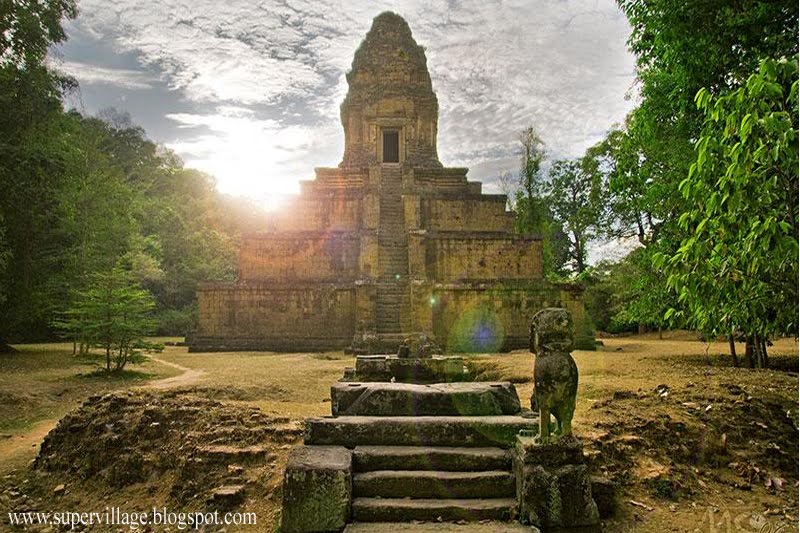
-Pre Rup Temple
-Top temple
-Leak Neang temple
-Eastern Mebon and Eastern Baray
-Ta Som Temple
-Krol Ko Temple
-Neak Pean Temple
-Preah Khan Temple
-Prey temple
-Banteay Prey temple
-Kraol Romeas temple
-Tonle Sgnuot temple
-Prey Prasat Temple
-Bonteay Thom Temple
-Tur Temple
-West Baray
-West Mebon Temple
-Ak Yum Temple
-Banteay Samre Temple
-Phnom Bok
-Banteay Srei (Citadel of the women) Temple
-Beng Mealea Temple
-Phnom Kulen
-Chup Preah
-Preah Ang Thom
-Phnom Krom
-Cambodian Cultural village
Angkor Wat

Angkor Wat (or Angkor Vat) , is a temple complex at Angkor, Cambodia, built for the king Suryavarman II in the early 12th century as his state temple and capital city. This site is the only one to have remained a significant religious centre since its foundation—first Hindu, dedicated to Vishnu, then Buddhist. The temple is the epitome of the high classical style of Khmer architecture. It has become a symbol of Cambodia, appearing on its national flag, and it is the country's prime attraction for visitors.

Angkor Wat combines two basic plans of Khmer temple architecture: the temple mountain and the later galleried temple, based on early South Indian architecture, with key features such as the Jagati.

It is designed to represent Mount Meru, home of the devas in Hindu mythology, within a moat and an outer wall 3.6 kilometres (2.2 mi) long are three rectangular galleries, each raised above the next.

At the centre of the temple stands a quincunx of towers. Unlike most Angkorian temples, Angkor Wat is oriented to the west; scholars are divided as to the significance of this. The temple is admired for the grandeur and harmony of the architecture, its extensive bas-reliefs and for the numerous devatas (guardian spirits) adorning its walls. The modern name, Angkor Wat, in use by the 16th century, means "City Temple": Angkor is a vernacular form of the word Nokor which comes from the Sanskrit word Nagara (capital), while Wat is the Khmer word for temple.

Prior to this time the temple was known as Preah Pisnulok, after the posthumous title of its founder, Suryavarman II.
History
Angkor Wat lies 5.5 km north of the modern town of Siem Reap, and a short distance south and slightly east of the previous capital, which was centred on the Baphuon. It is in an area of Cambodia where there is an important group of ancient structures.

It is the southernmost of Angkor's main sites.The initial design and construction of the temple took place in the first half of the 12th century, during the reign of Suryavarman II (ruled 1113 – c. 1150), Dedicated to Vishnu, it was built as the king's state temple and capital city. As neither the foundation stela nor any contemporary inscriptions referring to the temple have been found, its original name is unknown, but it may have been known as Vrah Vishnulok after the presiding deity. Work seems to have ended on the king's death, leaving some of the bas-relief decoration unfinished.In 1177 Angkor was sacked by the Chams, the traditional enemies of the Khmer.
Thereafter the empire was restored by a new king, Jayavarman VII, who established a new capital and state temple (Angkor Thom and the Bayon respectively) a few kilometres to the north. In the 14th or 15th century the temple was converted to Theravada Buddhist use, which continues to the present day. Angkor Wat is unusual among the Angkor temples in that although it was somewhat neglected after the 16th century it was never completely abandoned, its preservation being due in part to the fact that its moat also provided some protection from encroachment by the jungle. One of the first Western visitors to the temple was Antonio da Magdalena, a Portuguese monk who visited in 1586 and said that it "is of such extraordinary construction that it is not possible to describe it with a pen, particularly since it is like no other building in the world. It has towers and decoration and all the refinements which the human genius can conceive of”. However, the temple was popularized in the West only in the mid-19th century on the publication of Henri Mouhot's travel notes. The French explorer wrote of it:"One of these temples a rival to that of Solomon, and erected by some ancient Michelangelo—might take an honourable place beside our most beautiful buildings. It is grander than anything left to us by Greece or Rome, and presents a sad contrast to the state of barbarism in which the nation is now plunged." Mouhot, like other early Western visitors, was unable to believe that the Khmers could have built the temple, and mistakenly dated it to around the same era as Rome. The true history of Angkor Wat was pieced together only from stylistic and epigraphic evidence accumulated during the subsequent clearing and restoration work carried out across the whole Angkor site.
Angkor Wat required considerable restoration in the 20th century, mainly the removal of accumulated earth and vegetation. Work was interrupted by the civil war and Khmer Rouge control of the country during the 1970s and 1980s, but relatively little damage was done during this period other than the theft and destruction of mostly post-Angkorian statues. The temple has become a symbol of Cambodia, and is a source of great national pride.

Style
Angkor Wat is the prime example of the classical style of Khmer architecture—the Angkor Wat style which it has given its name. By the 12th century Khmer architects had become skilled and confident in the use of sandstone (rather than brick or laterite) as the main building material. Most of the visible areas are of sandstone blocks, while laterite was used for the outer wall and for hidden structural parts. The binding agent used to join the blocks is yet to be identified, although natural resins or slaked lime have been suggested. Angkor Wat has drawn praise above all for the harmony of its design, which has been compared to the architecture of ancient Greece or Rome. According to Maurice Glaize, a mid-20th-century conservator of Angkor, the temple "attains a classic perfection by the restrained monumentality of its finely balanced elements and the precise arrangement of its proportions. It is a work of power, unity and style." Architecturally, the elements characteristic of the style include the ogival, redented towers shaped like lotus buds, half-galleries to broaden passageways, axial galleries connecting enclosures, and the cruciform terraces which appear along the main axis of the temple. Typical decorative elements are devatas (or apsaras), bas-reliefs, and on pediments extensive garlands and narrative scenes. The statuary of Angkor Wat is considered conservative, being more static and less graceful than earlier work. Other elements of the design have been destroyed by looting and the passage of time, including gilded stucco on the towers, gilding on some figures on the bas-reliefs, and wooden ceiling panels and doors.The Angkor Wat style was followed by that of the Bayon period, in which quality was often sacrificed to quantity. Other temples in the style are Banteay Samré, Thommanon, Chao Say Tevoda and the early temples of Preah Pithu at Angkor; outside Angkor, Beng Mealea and parts of Phanom Rung and Phimai . The Archaeological Survey of India carried out restoration work on the temple between 1986 and 1992. Since the 1990s, Angkor Wat has seen continued conservation efforts and a massive increase in tourism. The temple is part of the Angkor World Heritage Site, established in 1992, which has provided some funding and has encouraged the Cambodian government to protect the site.

The German Apsara Conservation Project (GACP) is working to protect the devatas and other bas-reliefs which decorate the temple from damage. The organisation's survey found that around 20% of the devatas were in very poor condition, mainly because of natural erosion and deterioration of the stone but in part also due to earlier restoration efforts. Other work involves the repair of collapsed sections of the structure, and prevention of further collapse: the west facade of the upper level, for example, has been buttressed by scaffolding since 2002, while a Japanese team completed restoration of the north library of the outer enclosure in 2005.

World Monuments Fund began work on the Churning of the Sea of Milk Gallery in 2008. Angkor Wat has become a major tourist destination. In 2004 and 2005, government figures suggest that, respectively, 561,000 and 677,000 foreign visitors arrived in Siem Reap province, approximately 50% of all foreign tourists in Cambodia for both years. The influx of tourists has so far caused relatively little damage, other than some graffiti; ropes and wooden steps have been introduced to protect the bas-reliefs and floors, respectively. Tourism has also provided some additional funds for maintenance as of 2000 approximately 28% of ticket revenues across the whole Angkor site was spent on the temples although most work is carried out by foreign government-sponsored teams rather than by the Cambodian authorities.
Ta Prohm Kil Temple

Ta Prohm Kill temple is located on the way from Angkor Wat to Angkor Thom, about 300 meters from the west entry gat of Angkor Wat. The chapel made of sandstone that faces east. This temple was built in the late 12 th century, during the reign of King Jayavarman VII. According to an inscription found in 1928, the chapel of 102 hospitals built by King Jayavarman VII has the same form.
Phnom Bakheng Temple

Thnom Bakeng temple was built on the natural hill. Commonly referred to as temple-mountain because it is an earthly facsimile of Mount Meru, it is located on the left side of the road from Angkor Wat to Angkor Thom and attracts scores of tourists who come to watch the sunset or sunrise. The temple was cut from the rock that formed the natural hill and faced with sandstone in the late 9 th and early 10 th centuries, during the reign of King Yasovarman I ( AD 889-910 ), dedicating to Shiva Brahmanism. Phnom Bakheng is 65 meters high and the temple has 109 towers. Phnom Bakeng temple was a replica of Mount Meru and the number of towers suggests a cosmic symbolism. The seven levels – ground, five towers, upper terrace of the monument represent the seven heavens of Indra in Brahmanism mythology.

The temple must have been a spectacular site in its entirety because originally 108 towers were evenly spaced around the tiers with yet other one, the central sanctuary, at the apex of them all. Today, however, most of these towers have collapsed. Beside the central sanctuary, there were 4 towers on the upper terrace, 12 on each of the 7 levels of the platform, and another 44 towers around the base. The brick towers on the different levels represent the 12-year cycle of the animal zodiac. It is also possible that the numerology of 108 towers symbolizes the 4 lunar phases with 14 days in each phases. The arrangement allows for only 33 of the towers to be seen from each side, a figure that corresponds with the number of Brahmanism deities. At the top of the hill, Phnom Bakeng is set on a tiered platform of five levels.

There are stairways of very steep gradient all on four sides. Seates lions flank the step at the each of the five levels. The complex is surrounded by laterite rampart with Gopuras. Beyond there is a small structure to north with sandstone pillars in which there are two lingams. A modern footprint of the Buddha is in the center of the path. Two libraries are opening only to the west on either side of the part. At the top most platform of 76 meters square and 13 meters high, five towers are arranged in quincunx. The central towers once contained the lingam to which the temple was dedicated. It opens to all four cardinal points. The remaining four sanctuaries also sheltered lingams on pedestals and open on two sides.

The central sanctuary is decorated with female divinities set in niches at the corner of the temple which have delicately carved bands of foliage above; the pilasters are finely worked and have raised interlacing of figurines.

The makaras on the tympanums are lively and strongly executed. The decoration above the door is well preserved showing a panel of foliated cusps with the heads of 33 gods. An inscription is visible on the west side of the north door of the central sanctuary. According to an inscription on the temple, Phnom Bakeng was the center of the city of Yasodharapura. This fact was verified in the late 9 th century with the discovery of an old rampart. This temple was originally called Yasodharakiri. Later it was known as Phnom Kandal. It might have been the city Yasodharapura or because it is between Phnom Bok and Phnom Krom.

Today visitors refer to the temple as Phnom Bakeng. This name was found in an inscription on the temple in the 16 th century.
Baksei Chamkrong Temple
This small Hindu temple formerly housed a golden image of Shiva and can be spotted to the left when entering Angkor Thom from the Southern Gate. One of the very few brick buildings in Angkor, King Hasavarman I dedicated it to his father, Yasovarman I in 947 and the temple was completed by Rajendravarman II (944-968 AD) "The bird who shelters under its wings".

Baksei Chamkrong is located just north of Phnom Bakheng, a short distance between Angkor Wat and the South Gate of Angkor Thom. The name of this temple comes from a legend. In it, the king was trying to flee an Angkor under siege. Suddenly a huge bird swooped down and sheltered the king under its wings. This is one of the first temples to be constructed of durable material such as bricks and laterite, and with decorations in sandstone.

It affords a single-tower design on a square, four-tiered platform that rises to 12 metres high. Most of the stucco that once adorned this temple is now gone, and its lintels are also now in poor condition.
Rorng Romong Temple
Rorng Romong temple is southwest of Phnom Bakeng. A small brick temple, the upper part has been lost over time. According to local resident, the temple’s name comes from the traditional Khmer game Romong. Some people, however, say the temple was once used to house an animal called Romong. Such an animal does not exist today, however, and no one has ever seen a picture of it.
Thma Bay Kaek Temple

Thma Bay Kaek temple is located near the south moat of Angkor Thom and north of Baksei Cham Krong temple, about 125 meters from the entrance to Angkor Thom.This temple was built in the 10 th century to worship Brahmanism. No one knows who built the temple.
Bey Temple
Bey temple is located west of Thma Bay Kaek temple. Constructed of brick in the 10 th century , dedicating to Shiva Brahmanism, it has three towers and faces east. The original name of the temple is unknown. However, because it has three towers, it is call Bey Temple.
Angkor Thom

Angkor Thom was the last and most enduring capital city of the Khmer empire. It was established in the late twelfth century by king Jayavarman VII. It covers an area of 9 km², within which are located several monuments from earlier eras as well as those established by Jayavarman and his successors. At the centre of the city is Jayavarman's state temple, the Bayon, with the other major sites clustered around the Victory Square immediately to the north. Angkor Thom was established as the capital of Jayavarman VII's empire, and was the centre of his massive building programme. One inscription found in the city refers to Jayavarman as the groom and the city as his bride. (Higham, 121) Khmer capital on the site, however. Yasodharapura, dating from three centuries earlier, was centred slightly further northwest, and Angkor Thom overlapped parts of it. The most notable earlier temples within the city are the former state temple of Baphuon, and Phimeanakas, which was incorporated into the Royal Palace. The Khmers did not draw any clear distinctions between Angkor Thom and Yashodharapura: even in the fourteenth century an inscription used the earlier name. (Higham 138) The name of Angkor Thom (great city ) was in use from the 16th century. The last temple known to have been constructed in Angkor Thom was Mangalartha, which was dedicated in 1295. Thereafter the existing structures continued to be modified from time to time, but any new creations were in perishable materials and have not survived. In the following centuries Angkor Thom remained the capital of a kingdom in decline until it was abandoned some time prior to 1609, when an early western visitor wrote of an uninhabited city, "as fantastic as the Atlantis of Plato" which some thought to have been built by the Roman emperor TrajanAngkor Thom is in the Dom style. This manifests itself in the large scale of the construction, in the widespread use of laterite, in the back-towers at each of the entrances to the south cheack and in the naga-carrying giant monsters which accompany each of the towers.
Map of the Central Angkor Thom

The city lies on the right bank of the Siem Reap River, a tributary of Tonle Sap, about a quarter of a mile from the river. The south gate of Angkor Thom is 7.2 km north of Siem Reap, and 1.7 km north of the entrance to Angkor Wat. The walls, 8 m high and flanked by a moat, are each 3 km long, enclosing an area of 9 km². The walls are of laterite buttressed by earth, with a parapet on the top. There are gates at each of the cardinal points, from which roads lead to the Bayon at the centre of the city. As the Bayon itself has no wall or moat of its own, those of the city are interpreted by archaeologists as representing the mountains and oceans surrounding the Bayon's Mount Meru. (Glaize 81). Another gate ( the Victory Gate ) is 500 m north of the east gate, the Victory Way runs parallel to the east road to the Victory Square and the Royal Palace north of the Bayon.

The faces on the 23 m towers at the city gates (which are later additions to the main structure) take after those of the Bayon, and pose the same problems of interpretation. They may represent the king himself, the bodhisattva Avalokiteshvara, guardians of the empire's cardinal points, or some combination of these.

A causeway spans the moat in front of each tower: these have a row of devas on the left and asuras on the right, each row holding a naga in the attitude of a tug-of-war. This appears to be a reference to the myth, popular in Angkor, of the Churning of the Sea of Milk. The temple-mountain of the Bayon, or perhaps the gate itself, (Glaize 82) would then be the pivot around which the churning takes place. The nagas may also represent the transition from the world of men to the world of the gods (the Bayon), or be guardian figures. (Freeman and Jacques 76). The gateways themselves are 3.5 by 7 m, and would originally have been closed with wooden doors. (Glaize 82) The south gate is now by far the most often visited, as it is the main entrance to the city for tourists. At each corner of the city is a Prasat Chrung (corner shrine) built of sandstone and dedicated to Avalokiteshvara. These are cruciform with a central tower, and orientated towards the east. Within the city was a system of canals, through which water flowed from the northeast to the southwest.

The bulk of the land enclosed by the walls would have been occupied by the secular buildings of the city, of which nothing remains. This area is now covered by forest. The Bayon (Prasat bayon) is a well-known and richly decorated Khmer temple at Angkor in Cambodia.

Built in the late 12th century or early 13th century as the official state temple of the Mahayana Buddhist King Jayavarman VII, the Bayon stands at the centre of Jayavarman's capital, Angkor Thom. Following Jayavarman's death, it was modified and augmented by later Hindu and Theravada Buddhist kings in accordance with their own religious preferences.

The Bayon's most distinctive feature is the multitude of serene and massive stone faces on the many towers which jut out from the upper terrace and cluster around its central peak. The temple is known also for two impressive sets of bas-reliefs, which present an unusual combination of mythological, historical, and mundane scenes.

The main current conservatory body, the JSA, has described the temple as "the most striking expression of the baroque style" of Khmer architecture, as contrasted with the classical style of Angkor Wat.
History
The Bayon was the last state temple to be built at Angkor, and the only Angkorian state temple to be built primarily as a Mahayana Buddhist shrine dedicated to the Buddha, though a great number of minor and local deities were also encompassed as representatives of the various districts and cities of the realm. It was the centrepiece of Jayavarman VII's massive program of monumental construction and public works, which was also responsible for the walls and naga-bridges of Angkor Thom and the temples of Preah Khan, Ta Prohm and Banteay Kdei. The similarity of the 200 or so gigantic faces on the temple's towers to other statues of the king has led many scholars to the conclusion that the faces are representations of Jayavarman VII himself. Others have said that the faces belong to the bodhisattva of compassion called Avalokitesvara or Lokesvara. The two hypotheses need not be regarded as mutually exclusive. Angkor scholar George Coedès has theorized that Jayavarman stood squarely in the tradition of the Khmer monarchs in thinking of himself as a "devaraja" (god-king), the salient difference being that while his predecessors were Hindus and regarded themselves as consubstantial with Shiva and his symbol the lingam, Jayavarman as a Buddhist identified himself with the Buddha and the bodhisattva.The temple is orientated towards the east, and so its buildings are set back to the west inside enclosures elongated along the east-west axis. Because the temple sits at the exact centre of Angkor Thom, roads lead to it directly from the gates at each of the city's cardinal points. The temple itself has no wall or moats, these being replaced by those of the city itself: the city-temple arrangement, with an area of 9 square kilometres, is much larger than that of Angkor Wat to the south (2 km²). Within the temple itself, there are two galleried enclosures (the third and second enclosures) and an upper terrace (the first enclosure). All of these elements are crowded against each other with little space between. Unlike Angkor Wat, which impresses with the grand scale of its architecture and open spaces, the Bayon "gives the impression of being compressed within a frame which is too tight for it."The Bayon in plan, showing the main structure. The dimensions of the upper terrace are only approximate, due to its irregular shape.
Points of interest on the wall of Bayon Temple include:

-In the southern part of the eastern gallery a marching Khmer army (including some Chinese soldiers), with musicians, horsemen, and officers mounted on elephants, followed by wagons of provisions, Still in the eastern gallery, on the other side of the doorway leading into the courtyard, another procession followed by domestic scenes depicting Angkorian houses, some of the occupants of which appear to be Chinese merchants.

-In the southeast corner pavilion, an unfinished temple scene with towers, apsaras, and a lingam.

-In the eastern part of the southern gallery, a naval battle on the Tonle Sap between Khmer and Cham forces, underneath which are more scenes from civilian life depicting a market, open-air cooking, hunters, and women tending to children and an invalid.

Still in the southern gallery, past the doorway leading to the courtyard, a scene with boats and fisherman.

Also a Chinese junk, below which is a depiction of a cockfight.

Then some palace scenes with princesses, servants, people engaged in conversations and games, wrestlers, and a wild boar fight, then a battle scene with Cham warriors disembarking from boats and engaging Khmer warriors whose bodies are protected by coiled ropes, followed by a scene in which the Khmer dominate the combat, followed by a scene in which the Khmer king celebrates a victory feast with his subjects.
-In the western part of the southern gallery, a military procession including both Khmers and Chams, elephants, war machines such as a large crossbow and a catapult.

-In the southern part of the western gallery, unfinished reliefs show an army marching through the forest, then arguments and fighting between groups of Khmers.
-In the western gallery, past the doorway to the courtyard, a scene depicting a melee between Khmer warriors, then a scene in which warriors pursue others past a pool in which an enormous fish swallows a small deer; then a royal procession, with the king standing on an elephant, preceded by the ark of the sacred flame.
-In the western part of the northern gallery, again unfinished, a scene of royal entertainment including athletes, jugglers and acrobats, a procession of animals, ascetics sitting in a forest, and more battles between Khmer and Cham forces.-In the northern gallery, past the doorway to the courtyard, a scene in which the Khmer flee from Cham soldiers advancing in tight ranks.
-In the northeast corner pavilion, another marching Khmer army.
-In the eastern gallery, a land battle between Khmer and Cham forces, both of which are supported by elephants: the Khmer appear to be winning.
-The outer gallery encloses a courtyard in which there are two libraries (one on either side of the east entrance). Originally the courtyard contained 16 chapels, but these were subsequently demolished by the Hindu restorationist Jayavarman VIII.
-The upper terrace is home to the famous "face towers" of the Bayon, each of which supports two, three or (most commonly) four gigantic smiling faces.

In addition to the mass of the central tower, smaller towers are located along the inner gallery (at the corners and entrances), and on chapels on the upper terrace. "Wherever one wanders," writes Maurice Glaize, the faces of Lokesvara follow and dominate with their multiple presence." Efforts to read some significance into the numbers of towers and faces have run up against the circumstance that these numbers have not remained constant over time, as towers have been added through construction and lost to attrition. At one point, the temple was host to 49 such towers; now only 37 remain. The number of faces is approximately 200 faces of Lokesvara, but since some are only partially preserved there can be no definitive count. -The central tower and sanctuary rises 43 metres above the ground. At the time of the temple's foundation, the principal religious image was a statue of the Buddha, 3.6 m tall, located in the sanctuary at the heart of the central tower. The statue depicted the Buddha seated in meditation, shielded from the elements by the flared hood of the serpent king Mucalinda. During the reign of Hindu restorationist monarch Jayavarman VIII, the figure was removed from the sanctuary and smashed to pieces. After being recovered in 1933 from the bottom of a well, it was pieced back together, and is now on display in a small pavilion at Angkor.Preah Ang Kork ThlorkPreah Ang Kork Thlork or Wat Kork Thlork is located west of Bayon temple. According Khmer legend, Kork Thlork was the first name of Cambodia. An Indian named Preah Thaong was banished from his country. He threw a javelin to determine where he would live. His javelin landed on Kork Thlork Island. So he went to the island, where he met Neang Neak, whom he married. Neang Neak’s father, a sea naga king, inspired the sea and created a country that is known today as Cambodia.
Baphuon Temple
The Baphuon adjoins the southern enclosure of the Royal Palace.

Its outer eastern gopura lies on the same longitudinal axis as the Elephant Terrace, which also aligns with the central tower of the Bayon, located just to the south. The two temples differ in age and are not, however, related, but rather juxtaposed in an apparently aimless manner that suggests no ancient connection. On its three other sides the temple is surrounded by a moulded enclosure wall, constructed unusually in sandstone which, to the north, becomes a retaining wall since the embankment has been filled.

The dimensions of this rectangle are 425 metres by 125. Measuring 120 metres east-west by 100 metres north-south at its base, the temple-mountain of the Baphuon stands between the royal palace enclosure and the earth embankment which, bordering to the south, probably constituted the north bank of the moat surrounding the capital of Yasovarman, centred on Phnom Bakheng during the ninth century. Its considerable size would make it without doubt one of the more imposing of the Angkor monuments were it located on a less restricted site. This is "the Copper Tower higher even than the Golden Tower (the Bayon) a truly astonishing spectacle" described by Tcheou Ta-Kouan at the end of the 13th century. The Inscriptions of Lovek and Prah Ngok, found at the very foot of the Baphuon, enabled Mr Cœdes to identify this as the "golden mountain" (svarnadri) "an ornament of the three worlds" erected by Udayadityavarman II at the centre of his capital, and where, in a temple of gold, there stood a Shiva linga. Before its clearing, the Baphuon was but a vegetation covered mound that had suffered destruction by both natural and human forces. It appears today as a collection of crumbling structures, carried on powerful foundations, from which the gopuras emerge at mid height with their remarkably preserved sculpted walls and bas-reliefs. It is the first realisation in Angkor of a building with concentric stone galleries enclosing a central tower formed of an artificial earth mound retained by rough laterite walls clad in sandstone. Subsidence caused by water action has been unavoidable, despite some precautionary drainage.

The monumental three-part entrance, bordering the royal square, is composed of cruciform gopuras joined by galleries, all set on a decorated base platform, and is a precursor of the western entrance to Angkor Wat. Three lingas were found at the fourth enclosure on leaving the centre of the monument, where only some wall bases and dangerously leaning porticoes remain one in each passage.

There is then a sandstone causeway about 200 metres long formed as a sort of bridge with long paving stones laid on three lines of short columns, followed perhaps as a result of some miscalculation by a 5.5 metre wide dike, formed as an embankment between two lateral walls. At about two thirds of the way along this causeway, a badly ruined cruciform pavilion, which must have been decorated with bas reliefs, intersects the pathway. Two terraces extend to the north and south, the latter of which leads to a 37 by 28 metre pool surrounded by sandstone steps.

The temple itself is formed as a high, five tiered pyramid in sandstone which, in contrast to those of the 9th and 10th centuries, is rectangular in plan rather than square with the superimposed upper tiers not decreasing but practically constant in height, almost certainly so that the view of the top was not obscured by the galleries. These galleries surround the first, third and the fifth tiers. The top terrace is about twenty metres above ground level. The base walls, though powerfully moulded, are not sculpted. The outer gallery of the third enclosure has almost entirely disappeared, its materials having been used relatively recently to construct the outline of an enormous and almost shapeless reclining Buddha, on the western face of the upper levels, from a pile of blocks. Fortunately the gopura with bas-reliefs situated at mid height has simply been incorporated into this masonry without being demolished. The corner towers have been rased, as have almost all of the north and west gopuras. Entering the monument by the eastern gopura, where three passageways are served by steep stairs, one can see, over the connecting door between the central section and the north wing, evidence of a practice peculiar to this period of Khmer art and which often caused structural failure, that of cutting a channel in the sandstone lintel in order to set in a secondary wooden beam, whose time-worn remainsare still visible. This gopura is larger than the three others of this entrance, having a central tower and doubled wings with barrel-formed vaults.

Continuing past the remains of two cruciform "library" type buildings with four vestibules, once linked to one another by a narrow walkway raised on columns similar to those at the second level of Angkor Wat, and which one can find again, though less developed, on the western side one reaches the south gopura. This is in a better state of preservation, and has a decoration, as before, of foliated scrolls, flowers and animals and of charming "hipped" devatas. There is also, in an unusually small panel, an ascetic who seems deliberately to depart from the austerity of his normal life. Concrete steps alleviate the southern stairs where the treads, richly ornate and much worn as on the other sides are of a difficult height to negotiate and climb, there being no intermediate landing between the tiers. The second level has its enclosure of narrow galleries almost intact, with windows on the two sides walled in and decorated with balusters to the exterior. The vaulted roof, in contrast to that of Phimeanakas, has a central joint, and the piers are treated decoratively as pilasters. The corner towers have disappeared except for some remnants of wall supported by props in the southeast corner. The gopuras have a central tower with two upper tiers and three wings, the walls of which are sculpted in remarkable bas-reliefs that are worth a close look (see the following description). The lotus bud crown of the south gopura is almost preserved in its entirety, and its purity of line makes it one of the best examples of this type of motif to be found throughout the various periods of Khmer art.

The proximity of the following tier makes the internal courtyard of the second level more of a narrow corridor that is further reduced by the presence, on each side, of the three access stairs to the third level, which again climb the height of two tiers. To avoid the steep steps one can take, just to the west of the southern gopura, an easier stairway, amongst the rubble of the south-west corner of the pyramid's upper tier. The top platform, of 42 by 36 metres, has suffered a number of slides, and there now only remains a small part of the gopuras with their central tower and two wings. Their walls beautifully sculpted with a decoration animated with figurines. Here, a remaining part of a tower in the north-east corner and some bases of wall and gallery pillars give the only indication of the layout. These galleries have the peculiarity of being divided in two along their longitudinal axis by a partition pierced by balustered windows, a unique arrangement that must have given the illusion of a gallery on pillars, which was a formula still unknown at that time. The view to the eastern access causeway, to Phnom Bakheng to the south, to the Phimeanakas on the same axis to the north and out over the forest of Angkor is particularly pleasant. Nonetheless, one should not forget to admire the architectural qualities of the base platform of the central sanctuary, whose superstructure must have been constructed in light-weight materials and golden in colour in accordance with descriptions of the time.

one square in plan enclosing another that is cruciform with each having an ornamentation of a quality that puts them with the very best of the classical art. The existence of this hidden base platform was perhaps caused by an alteration in the setting out that was designed to increase the volume of the central tower or else as we have seen at the Bayon in order perhaps to emphasise in symbolic form the character of the temple-mountain as mount Meru, which continues under the ground in equal proportion to its elevation above.
Phimeanakas Temple
Prasat Phimeanakas (celestial temple) at Angkor, Cambodia, is a Hindu temple in the Khleang style, built at the end of the 10th century, during the reign of Rajendravarman (from 941-968), then rebuilt by Suryavarman II in the shape of a three tier pyramid as a Hindu temple.
On top of the pyramid there was a tower. According to legend, the king spent the first watch of every night with a Naga girl in the tower, during that time, not even the queen was permitted to intrude.

Only in the second watch the king returned to his palace with the queen. If the naga who was the supreme land owner of Khmer land did not show up for a night, the king's day would be numbered, if the king did not show up, calamity would strike his land.Royal PalaceSet off on the eastern side by the Terrace of the Elephants lies just north of the Baphuan, surrounded by a 6 meter high wall.

Remodeled more than once by successive monarchs, time and the encroaching jungle have left their mark on the stones and the palace is now in poor condition.
Terrace of the Elephants
The Terrace of the Elephants is part of the walled city of Angkor Thom, a ruined temple complex in Cambodia.

The terrace was used by Angkor's king Jayavarman VII as a platform from which to view his victorious returning army. It was attached to the palace of Phimeanakas which only a few ruins remain. Most of the original structure was made of organic material and has long since disappeared. Most of what remains are the foundation platforms of the complex.

The terrace is named for the carvings of elephants on its eastern face.The 350m-long Terrace of Elephants was used as a giant reviewing stand for public ceremonies and served as a base for the king's grand audience hall. It has five outworks extending towards the Central Square-three in the centre and one at each end.

The middle section of the retaining wall is decorated with life size gouda and lions, towards either end are the two parts of the famous parade of elephants complete with their Khmer mahouts.
Terrace of the Leper King
The outer terrace has five tiers of statues but the real surprise is the inner terrace that was buried for hundreds of yearsWinding along a narrow passage way, the inner terrace is covered with perfect carvings that positively leap out at the passers, built by Jayavarman VII in the late 12th century.

The terrace of the Leper King lies just to the north of the Terrace of the Elephants, aligned with it but standing separate. A mound of masonry about 25 metres across by 6 high, it is formed as a redented bastion with sides that are lined in sandstone and entirely sculpted with figures in a high relief, juxtaposed and separated in seven registers, the uppermost of which has almost entirely disappeared. Although now standing isolated, joined only at its north and south by the start of some returning walls, it is probable that this motif was previously but one element in a vast composition, perhaps complemented with pools, that has evidently undergone alteration.The clearing work has revealed the existence, at two metres behind the outer face and following its line, of a second system of walls, also sculpted in bas-reliefs that are identical in composition, the void between them was filled with laterite that had to be extracted by pick. The fact that some of the sculptures on the internal wall remain in rough form and that the start of its north-south return towards the Elephant Terrace seems to align with it leads one to suspect that there must have been a simple modification to the plan, perhaps decided during the course of the work by a sovereign who was little concerned with practicalities of construction. It is not impossible, however, that this curious arrangement was a response to some symbolic preoccupation with the concept of Mount Meru with the buried wall representing the underworld of the cosmic mountain, balanced by its volume visible in elevation.Whatever the reason, both the internal and external bas-reliefs are intentionally monotonous in presentation.

They show only lines of seated figures, apparently representing the various fabulous characters, Naga, Garuda, Kumbhanda which haunt the flanks of Mount Meru, shown as giants (sometimes with multiple arms), sword or club bearers, and women with bare torsos whose costume and triangular head dress with flaming discs relate to the style of the Bayon. To appreciate the exterior reliefs, the visitor should not forget to examine the north side, the best preserved and its northern return that runs parallel to the road, where the start of some palace scenes are treated in quite a different spirit. One can see here in particular a sword swallower and some followers wearing a curious sidechignon. Returning to the south side, one enters the internal corridor where the decor, set on a lower frieze of fish, elephants and the representation of a river running vertically, follows with the same elements as the exterior but is here enhanced with apsaras. Long protected, the sculpture remain very well preserved. At the end of the scene some laterite steps allow access to the upper level of the terrace.Surrounded by three smaller decapitated statues carrying clubs on their right shoulders, the "Leper King" sits in the Javanese manner with his right knee raised. Resting on a simple stone slab just where he was found and which perhaps corresponds to his original position, he offers the peculiarity that he is entirely naked a unique phenomenon in Khmer art, though with no indication of any genitalia. He also has no sign of leprosy other than a few patches of lichen his celebrity being more literary than artistic. Uninspired in craftsmanship and a little foppish in nature, he must rank amongst average works without attaining the first order.

The statue of the "Leper King", held by some to be a representation of "Shiva ascetic" is perhaps, in fact, if one is to believe a short 15th century inscription on the base a "Dharmaraja". This name is sometimes given to Yama and sometimes to one of his assessors "the Inspector of Qualities and Faults" the supreme judge in the hour of judgement. From the north-west corner of the Terrace of the Leper King one can then reach the Large Buddha of Tep Pranam along a track without having to re-descend it.
Tep Pranom Temple
The terrace lies east of Preah Palilay, a temple built by King Yasovarman VII to the north of the Royal Palace. A 4.5 meter high statue of Buddha survives. Several monks live in a wooden monastery nearby while another building houses nuns widowed under the Pol Pot regime."The adoring god"From the road, a hundred meters north of the Terrace of the Leper King, one can see the large sitting Buddha of Tep Pranam at the end of a long cutting through the forest.

One gains access along a laterite pavement of 75 meters by 8, after which is a typical Buddhist terrace delimited with "sema", or doubled steles, placed at the corners and on the axis. Fifty meters long by fourteen wide, the western end of this terrace terminates with a cruciform platform of 30 meters by 30. The moulded walls of its plinth are in sandstone, as is part of its paving.

Two lions in the style of the Bayon precede it to the east side, while the nagas of its balustrades date from an earlier period.A stele inscribed on its four sides, found in the vicinity but whose true origin is unknown, tells of its ancient Buddhist monastery or "asrama" (Saugatasrama) founded by Yasovarman towards the end of the 9th century. The text defines the various rules of organisation - that are almost identical to those of the Shivaïte "Brahmanasrama" and of the "Voirsnavasrama" founded by the same king to the south of the eastern baray. The buildings were certainly constructed in light-weight materials and one can find, on either side, the remains of funerary monuments or "cedei", as well as two stone tanks.Set on a 1m.00 high moulded base, the statue itself is formed in assembled blocks and reaches to a height of 6m.00 - an enormous Buddha, sitting on a lotus and "calling the earth to witness". Constructed from a number of re-used stones, the body has the look of a rough-formed model whose head with its "ushnisha" topped by a flame, is certainly of a late period.Just to the west of Tep Pranam are the remains of a pool with laterite steps, next to which it has been possible to reconstruct another large standing Buddha, over 4m.00 in height and making the ritual gesture of "absence of fear". His face has not been found.
Preah Palilay
Pictur esque sandstone and laterite tower in a cool, shaded forest setting, in the area behind the Terrace of the Leper King. The central tower is in rough condition but the eastern gopura displays some particularly nice Buddhist-themed carvings.

The date of construction is a matter of some debate. Traditionally dated to the late 12th/early 13th century, but the Theravadan Buddhist themes of some of the carvings and some architectural features suggest a construction date in the late 13th or 14th century. The tower was rebuilt and modified in the post-Bayon period.
Preah Pithu Temple
Preah Pithu is a group of temples located northeast of the Terrace of the Leper King. Studies of their style indicate that all except one are Brahman temples build during the 12 th century by King Surayavarman II. The lone Buddhist temple, built sometime between the 13 th and 14 th centuries, has many Buddha bas-reliefs and other signs related to Buddhism.Most of structures are in poor condition, but their bases remain and, from the evidence, the temples were of excellent quality in design, workmanship and decoration.

Preah Pithu temple consist of two cruciform terraces and five sanctuaries situated in seemingly random order amongst ramparts, moats and ponds. All the shrines are square with false door, stand on a raised platform and are oriented to the east.
Suor Proat Temple

Suor Proat Temple is located at the beginning of the road leading to the Gate of Victory of Angkor Thom, 1,200 meters (3,937 feet) in front of Phimeanakas. A enter and leave the towers from the road at the east. It was built in the end of the 12th century by the King Jayavarman VII, replica to Bayon style of art. The purpose of these towers is a source of some controversy. According to a Cambodian legend, the towers swerved as anchoring places for ropes which stretched from one to another for acrobats performing at festivals, festivals, while the king observed the performances from one of the terraces. This activity is reflected in the name of the towers. Zhou Daguan wrote about an entirely different purpose of the towers in describing a method of settling disputes between men.Twelve little stone towers stand in front of the royal palace. Each of the contestants is forced to de seated in one of the towers, with his relatives standing guard over him. They remain imprisoned two, three, or four days. When allowed to emerge, one of them will be found to be suffering saome illness- ulcers, of catarrh, or malignant fever. The other man will be in perfect health. Thus is right or wrong determined by what is called 'celestial judgment'Henri Mouhot wrote that the towers were 'said to have been the royal treasure. It served, they, as a depository for the crewels. Another theory is that they may have served as an altar for each province on the occasion of the taking of the oath of loyalty to the kingPrasat Suor Prat is a row of 12 square laterite and sandstone towers, six on either side of the road leading to Angkor Thom, parallel to the front of the terraces. The two towers closest to the road are back slightly from the others. The towers are connected by galleries and are of similar style and construction. The towers have an unusual feature of windows with balusters on three sides.

Entrance porches open toward the square and the road to the Gate of Victory of the city of Angkor Thom. These features support the theory that these towers were used as some sort of viewing area, reserved for princes or dignitaries, on to the large square of the Royal Palace, The interior of each tower has two levels and two levels and on the upper one there is a cylindrical vault with two pediments. The frames, bays and lintels were made of sandstone.
Khleang Temples

The Khleang Temples are two buildings of unknown purpose on the east side of the Royal Square in Angkor Thom, Cambodia, located just behind the twelve towers of Prasat Suor Prat and separated by the royal route that leads from the Royal Palace to the Victory Gate. They are oriented along the north-south axis. The two were not built at the same time.

The northern building (North Khleang) was built under King Jayavaraman and the southern (South Khleang) under his successor Suryavarman I but they are of similar design (although South Khleang is slight narrower). They have given their name to the Khleang style, which is characterised by relatively simple lintels with a central kala. Other buildings in the style are Phimeanakas and Ta Keo.Rectangular sandstone buildings set opposite the Elephants Terrace, behind the Prasat Suor Proat.

‘Khleang’ means ‘storeroom’ but it is unlikely that this was the function of the structures, A royal oath of allegiance is carved into the doorway of one Khleang indicating that they may have served as reception areas or even housing for visiting noblemen and ambassadors. The North Khleang was built in wood under Rajendravarman II and then rebuilt in stone by Jayavaraman V, probably before the construction of the South Khleang. The Khleangs are unremarkable upon close inspection but picturesque from a distance, standing among the Prasat Suor Proat. Best photographed in the afternoon.
Thommanon Temple

Thommanon temple is about 500 meters east of the Victory Gate. A temple dedicated to Brahmanism, it was built in the late 11th and early 12th centuries by King Suryavarman II.

The temple is rectangular in plan with a sanctuary opening to the east, a moat and a rampart with two gopuras, one on the east and another on the west, and one libray near the south-east of the wall. Only traced of a laterite base of the wall remain.
Chao Say Tevoda Temple

Chao Say Tevoda is a temple at Angkor, Cambodia. It is located just east of Angkor Thom, across the Victory Way from Thommanon (it pre-dates the former and post-dates the latter). Built in the mid-12th century, it is a Hindu temple in the Angkor Wat style. As of 2005 it was under restoration by a Chinese team, and access was restricted.
Ta Keo Temple

Ta Keo Temple is located east of Thommanon Temple and Chao Say Tevada Temple on the east bank of Stung Siem Reap. any stone vault. It is probable, to judge by the rubble found during clearing works and the existence of corbelled brick vaults on the wings of the gopuras a technique similarly used at Banteay Srei and on the entry pavilions of the Royal Palace that the galleries at Takeo were themselves also vaulted in brick, rather than in any light-weight structure.The access to the monument from the east is gained across a moat by means of a paved causeway, preceded by lions in the style of the Bayon and lined with bornes. If one follows its extension to the east for 500 metres to the bank of the eastern baray one comes to a terrace on two levels. The external enclosure wall forms a rectangle of 120 metres by 100 and is in sandstone on a laterite base. The gopura all in sandstone and partially sculpted has three independent passageways and a central tower with reducing upper tiers. Frontons reconstructed on the ground show the style of the purely ornamental decoration. From the courtyard, open to the faithful, the view of the pyramid was entirely masked by the gallery of the next high tier.

To the east, on either side of the axis, long rooms of 22 metres by 2m.75 served perhaps to shelter pilgrims. Preceded by a portico and followed by a smaller annexe, each was covered in wood and tiles and illuminated by a series of windows on either side with slender balustrades. The second terrace dominates the first by 5m.50 in height with an imposing moulded laterite base and four axial sandstone gopuras. It is gained by steps of 0m.40 in height. To the east, the stone has received the beginnings of an ornamentation on the upper elements. The surrounding sandstone gallery, of 80 metres by 75 and 1m.40 in width, has no external openings and is only lit by windows towards the interior, the exterior being decorated with false balustered windows. There remains no trace of vault nor roof covering only the corner pavilions, which are less prominent, are vaulted in sandstone. The offsetting of the pyramid's axis towards the west has enabled the placing on the eastern side of two buildings, similar to the long rest rooms on the first terrace, though much less developed and poorly lit, and also of two "libraries" which open to the west and have a false upper storey pierced by long horizontal windows. Again there remains neither vault nor roof covering.From the courtyard, standing in front of the three tiers that form the 14 metre high central pyramid, one is struck with a powerful impression. The stairs are, abnormally of a constant width and rise in a single flight with steps from 0m.40 to 0m.30 in height, while their retaining walls to either side ascend in six steps. The strong moulding of opposing diamonds with a broad central roll gives a sense of force without detracting from the other elements of the decoration. Though only applied on the eastern side, and there badly damaged, this is remarkable in its composition, sculpted on a base of large flaming scrolls and horizontal diamonds. A rather scrawny Nandin (sacred bull) was found at the foot of the eastern stairway, confirming the Shivaïte destination of the temple. The upper platform is 47 metres square and almost entirely occupied by the quincunx of towers in their unfinished form. These open to the four cardinal points by means of as many projecting vestibules which are doubled for the central sanctuary. The corner towers are set on a 0m.80 plinth and are clearly dominated by the central tower. This is raised by 4 metres, with the further development of its porticoes and frontons adding to its grandeur. The internal sanctuary chambers measure 4m.00 and 3m.50 each side respectively. They are remarkably constructed and have the inside of their upper tiers carefully faced, with no decoration other than an elegantly sculpted internal cornice. Fragments of pedestals and of lingas have been found both in and around the towers, as have several statues.Because of its orientation, a visit to Takeo should best be made in the morning, and early so that its abrupt stairs do not appear too daunting. Chapel of the hospital temple 102 hospitals were built throughout the empire under Jayavarman VII. The hospital itself was probably constructed of perishable materials such as wood and bamboo, which has long since disappeared, leaving only the sandstone hospital temple or ‘chapel’ for the ages. This temple and the one at Ta Prohm Kel opposite Angkor Wat offer two examples of hospital temples. Constructed of sandstone, this Chapel of the Hospital is in rough condition but some carvings are still visible. A quiet, meditative spot, easily accessible but visited by few tourists.
Spean Thma temple

Spean Thma Temple is about 100 meters west of Ta Keo Temple. It is bridge constructed of reused blocks of sandstone to replace an earlier bridge.

The bridge is supported on massive pillars, the opening between them spanned by narrow corbelled arches. Reportedly, there are traces of 14 arches.
Taney temple

Taney temple is located in the forest, about 800 meters east of Ta Keo temple. It is accessible by small truck or vehicle. The temple was built in the late 12th century by King Jaya¬varmann VII. The original name of the temple is not known, but according to the local people, the name may have come from an old man named Ney who cared for the temple. This explanation is plausible, because most of the temples at Angkor are not called by their original names.
Top temple
Top temple is located in the forest northwest of Takeo temple near Ta Prohm temple. Like Ta Keo temple, Top Temple is constructed of large sandstones.
Ta Prohm Temple

Ta Prohm Temple is located about 1 kilometer east of the Victory Gate, southeast of of Ta Keo Temple. Its rampart is near the northwest corner of the rampart of Banteay Kdey Temple. The temple was built in AD 1186 by King Jayavaraman VII, dedicating to his mother.

Shrouded in jungle, Ta Prohm Temple is is ethereal in aspcet and conjoures up a romantic aura.Trunks of trees twist amongst stone pillars. Fig, bayan and kapok trees spread their gigatic roots over, under and in between the stones, probing walls and terraces apart, as their branches and leaves interwine to form a roof above the structures. The Sanskrit inscription on stone tells something about its size and fuction. Ta Prohm Temple owned 3,140 villages. It took 79,365 people to maintain the temple including 18 high priests, 2,740 officals, 2,202 assistants and 615 dancers.

Among the property belong to the temple was a set of golden diskes weighing more than 500 kilograms, 35 diamonds, 40,620 pearls, 4,540 precious stones, 876 veils from China, 512 silk beds and 523 parasols.The monastic complex of Ta Prohm Temple is a series of long, low building standing on one level conected with passages and concentric gallaries framing the main sanctuary.

A rectangular, laterite wall, which is 700 by 1,000 meters enclose the entire complex. The east entrance id signaled by a gopura in the outer rampart of the temple. There id a sandstone hall just north of the gopura known as the Hall of Dancers which is distinguished by large, square pillars. The central sanctuary itself is easy to miss and stands out because of its absence of decoretion. The stone has been hammered, possibly to prepare it for covering stucco and gilding, which has since fallen off. This accounts for the plainness of the walls of this important shrine. Evenly spaced holes on the inner walls of the central santuary suggest they were originally covered with metal sheets.
Banteay Kdey Temple

is located southeast of Ta Prohm Temple. The temple was built by the great King Jayavarman VII. The temple is similar in art and architecture of Ta Prohm Temple, but it is smaller and less complex. It is unknown to who this temple was dedicated as the inscription stone has never been found. According to archeologists, the original basic plan of the temple including a central sanctuary, a surrounding gallery and passageway connected to another gallary.

A moat enclose the temple, another rapart which is 700 by 500 meters is made of laterite and has four gopurs in the Bayon style, each with four faces looking in the cardinal directions, and garudas placed at the corners of each gopura, a favorite design of King Jayavaraman VII.

These gopuras are of the same style as those at Ta Prohm Temple. Research conducted by the University of Sofia has indicated that this temple was built on another older temple, as evidenced by a foundation base found under Banteay Kdey Temple.
 Archeologists believe the foundation may be related to Kod village during the reign of King Jayavaraman II.
Kodku Temple
Kodku Temple ( The owner of the main residence ) is located in the Rohal Village east of Ta Prohm. It was originally built in the 9th century during reign of king Jayavarman II. It was later reconstructed in the 10th century during the reign of king Rajendravarman. Shrouded in jungle, the temple features three brick towers that face east.
Prasat Kravan Temple

Prasat Kravan is a temple at Angkor, Cambodia, located south of the Srah Srang baray. The remains, reconstructed in the 19th century by the French, consist of five brick towers on a raised platform, while the exterior is unremarkable, some of the interiors feature unusual brick bas-reliefs. The central tower features bas reliefs of Vishnu in his form as Vamana as well as the god astride his mount, Garuda, both flanking a monumental eight-armed depiction.

The northernmost tower features a bas relief of Lakshmi, Vishnu's consort. The goddess holds both the trident of Shiva and the discus of Vishnu, possibly marking her as the great goddess who transcends the duality of Saiva and Vaishnava worship.

A more traditional depiction of Lakshmi holding lotuses is on the opposite wall.
Bat chum Temple

Bat Chum temple is located about 300 meters south of Srah Srang. It is accessible by Beung Mealir ancient road, which is located north of Kravan village.

Constructed of brick, the temple has three towers that face east. According to the inscription, the temple was built by a Buddhist officer named Kavey Treanrimthon during the reign of Rajendravarman, who crowed in AD 953, the temple was originally called Saok Takrum.
 It is now called Bat Chum.
Pre Rup Temple

Pre Rup is a temple at Angkor, Cambodia, built as the state temple of King Rajendravarman and dedicated in 961 or 962. It is a temple mountain of combined brick, laterite and sandstone construction. Located just south of the East Baray, or eastern reservoir, Pre Rup is aligned on a north-south axis with the East Mebon temple, another creation of the reign of Rajendravarman.

Pre Rup was dedicated to the Hindu god Shiva. Its extensive laterite and brick give it a pleasing reddish tone that is heightened by early morning and late afternoon sunlight. The temple has a square layout and two perimeter walls. A laterite causeway gives entry from the east, unfortunately, a modern road cuts across it.

To either side inside the eastern gate is a group of three towers aligned north to south, one of the towers appears to have never been built or to have been dismantled later. Further ahead, through another gate, libraries lie to either side of the walkway. Steps lead toward the top level, with carved sitting stone lions arrayed at intermediate stages. At the top, five towers are arranged in a quincunx pattern. one at each corner of the square and one in the center. Deities carved as bas reliefs stand guard at either side of the central tower’s eastern door, its other doors are false doors. The temple has significant detailed carving in various places in one scene, the god Indra stands atop his three-headed elephant.

The temple’s name is a comparatively modern one meaning “turn the body." This reflects the common belief among Cambodians that funerals were conducted at the temple, with the ashes of the body being ritually rotated in different directions as the service progressed. Some archeologists believe that a long stone container at the base of the main eastern stairs of the temple was used in funerals.
Leak Neang temple

Leak Neang temple is located near the northwest part of Pre Rup temple, about 100 meters east of the entrance to Ta Prey village. Constructed of brick, the temple faces east. It was built in the second half of the 10th century in AD 960, by King Rajendravarman. Eastern Mebon and Eastern BarayRajendravarman II dedicated the structure to his parents in 952. The red temple-mountain has three levels topped with five towers. At sunset the monument takes on a reddish glow. The sandstone elephants are in fine condition as well. In the now dry East Baray (7 x 1.8 km), the structure was formerly an island accessible only by boat. The lintels of the towers are particularly exquisite. Pre Rup and the Eastern Mebon were the last brick monuments built. Five hundred metres north of Pre Rup, the 16th kilometre boundary stone stands at the southern edge of the large expanse of water known as the eastern baray. Measuring two kilometres north-south by seven kilometres east-west, it is enclosed by an earth embankment and marked at each of its four corners with a stele set in a shelter. Identified as the "Eastern Lake" by Tcheou Ta-Kouan and the "Yasodharatataka" on the inscriptions, it was realised during the reign of Yasovarman towards the end of the 9th century and supplied by the Stung Siem Reap. This vast reservoir, that served to regulate the flow of the river and to irrigate the surrounding plain, is today given over to rice fields, though if one is to judge by the laterite steps which surround the small island of the Mebon, its original depth was three metres and its volume must have been 40 million cubic metres.

Since a large part of it is now silted up there must have been some disaster or rupture of a dike to have caused its rapid choking rather than its slow sedimentation. Whatever the cause, its centre was marked by a small island of 120 metres across where the temple of the Mebon was raised. on which the main entry pavilion of the Royal Palace of Angkor Thom and the Victory Gate were subsequently aligned. The Mebon has all the characteristics of a "temple-mountain" symbolising the Meru, but where there should have been the tiered pyramid inside two concentric enclosing walls, here there is instead a simple three metre high platform carrying the quincunx of towers. Perhaps the builders were wary of putting too much burden on such a small mound of earth entirely surrounded by water, Whatever the reason, in allowing a more open composition and in reducing the movement of pilgrims to a minimum. it was only accessible by boat, such an arrangement must have considerably eased the circulation.Several inscriptions found in the vicinity as well as the foundation stele, dated 952 and so only nine years before Pre Rup, describe the placing in the various sanctuaries of the linga Shri Rajendresvara, of several idols, notably of Shiva and Parvati "in the likeness of the mother and the father" of king Rajendravarman, and of Vishnou with Brahma, and of eight lingas of the god in eight forms (in the eight small towers of the surrounding court). The Mebon belongs therefore to the series of temples consecrated to the memory of deified parents and a very fine statue of a feminine divinity found during the course of clearing and returned to the sculpture storeroom would seem to be the Parvati of the inscription.Each axis is marked by a laterite embarkation terrace, framed by two sitting lions and forming projections from the retaining wall, itself supported on tiers. A border of five metres surrounds the external enclosure wall which, by the pleasing arrangement of its setting back, leaves sufficient space in front of each of the four gopuras. These are in laterite and sandstone with no remains of either vaults or roofs, cruciform in plan with three passageways and central sandstone porticoes. The inscribed stele is to be found on the right on entering. A series of galleries with laterite walls pierced by variously arranged balustered windows and with sandstone porticoes follows the interior of the enclosure wall, serving as meditation or rest rooms. They are, as at Pre Rup, the precursor of the continuous galleries that were soon to make their appearance in the monuments. Except for in the southern part, there are but a few remains of these buildings, whose roof covering was in timber and tiles. Perhaps the materials were put to some other use after their demolition. A 2m.40 high laterite retaining wall with a 2m.00 surrounding border defines the next level (first enclosure) which carries a low enclosing wall. One should not forget to admire, standing at the four corners of the platform of the first and second enclosures, the handsome monolithic elephants, treated in realistic fashion and showing every detail of their harnesses. The best preserved are to be found to the south-west, and are more impressive than those at Bakong.Ahead of the axial stairways, flanked by lions, a return in the enclosure wall again frames each gopura except for the western where the border has been left wider. The building itself, in laterite and brick, formed a towered passageway, though this has virtually collapsed. The western lintel of the east gopura shows Krishna wrestling with the naga. Within the large courtyard of the first enclosure, eight small brick towers, two on each side open to the east. Each sheltered a linga. They have finely detailed octagonal colonnettes with two bands, and lintels with figurines incorporated into a foliate decoration. To the east are three rectangular buildings in laterite, two to the south of the axis that contained in one a "stone of the nine planets" and the other a "stone of the seven ascetics" and a single one to the north. They open to the west like the "library" buildings, and traces of brickwork remaining above the cornice suggest that they were vaulted in brick despite their width. In the north-west and south-west corners are two similar buildings, without windows, but opening to the east. The upper platform carrying the five towers is surrounded by a sandstone wall forming a plainly moulded base of 3m.00 in height. Another plinth of 1m.90, but which is ornate, allows the central sanctuary to dominate the four others. All were covered with a sculpted lime-based mortar that is mentioned in one of the inscriptions, but of which there remains no trace, despite the measure taken of boring small holes in the brickwork to aid adhesion. The towers open to the east, with the other three false doors in sandstone. The sanctuary chamber measures 4m.00 in the central and 2m.80 in the corner towers. The one to the south-east still contains an interesting circular pedestal of the type already found at Phnom Bok and at Phnom Krom, where it carried a statue of Brahma. The ornamentation is similar in many ways to Pre Rup, and all the sculpted sandstone elements are remarkable, even though the decoration remains slightly affected and is occasionally reminiscent in its complexity of certain failings in the Baroque style.

The false doors are delightful with their lattice-work pattern and banded motifs set with tiny figurines. It has been possible to secure the lintels in place nearly everywhere during the course of the works. These are far better than those at Pre Rup and are handled with real craftsmanship, vigour and imagination. On the central tower, one should particularly note to the east, Indra on a three headed elephant with small cavaliers on the branches and flights of figures being disgorged by makaras, under a small frieze of figures in meditation to the west, Skanda the god of war on his peacock with a line of figures holding lotus flowers and to the south, Shiva on the sacred bull Nandin. Then on the tower of the north-west corner, east side, the curious motif of Ganesha sitting astride his trunk that he has transformed into a mount. On the tower of the south-east corner, north side, the head of a monster devouring an elephant. On the west gopura of the first enclosure, east side, Vishnou in the form of a man-lion, clawing the king of the Asuras who dared to challenge him. On the building of the north-east corner of the first enclosure, west side, Lakshmi between two elephants who, with their raised trunks, spray her with lustral water.
Ta Som Temple

Jayavarman built this Buddhist temple in the 12th century. Three wall flanked by four-faced towers protect it. The small scale offers the chance to absorb fully the perfection of design. Don't miss the picturesque East Gopura, held together by roots of a tree growing from the top. The Khmer Rouge reputedly once used the temple as a hospital. "The ancestor Som"From the eastern Mebon, Ta Som appears on the right, a little after the 13th kilometre marker stone, as a tower with four faces of Lokesvara entwined within the roots of a giant Ficus tree that crowns it perfectly. Several of the roots have pierced the vault and descend straight to the ground, obstructing part of the passageway. Cruciform in plan, this gopura is flanked by two small rooms and adjoins the 200 by 240 metre laterite wall of the external (the third) enclosure. Its western lintel shows the standing bodhisattva surrounded by worshippers. There is a similar gopura to the east with the same fronton, preceded externally by a small terrace bordered with naga-balustrades, the temple having a double entrance. Ta Som lies on the extension of the Prah Khan Neak Pean axis, and must represent, in its diminutive size, a single unified development typical of the monuments appearing in the last period of the style of the Bayon. It appears to be exactly like the external enclosures of Ta Prohm and of Banteay Kdei. In all its parts the same elements recur false windows with lowered blinds, small devatas which are rough and rustic and an embroidery of organic decoration on a background of foliated scrolls in profusion on the walls. In an advanced state of ruin, the various buildings which still stand have been the object of some provisional consolidation and basic clearing work. The internal courtyard remains littered with fallen blocks and the ensemble is, in its verdant setting, quite charming. After the first gopura, a pavement bordered by nagas with large garudas crosses the moat. The laterite wall of the second enclosure is cut to the east and west by cruciform sandstone gopuras, each with small wings to either side and open only to the outside with balustered windows. Preceded by porticoes, they are covered by a crossing of barrel-formed vaults. The first enclosure is formed by a gallery of 20 metres by 30. These are built in laterite and sandstone, as are the corner pavilions with their crossing vaults and moulded false doors. The four gopuras, entirely in sandstone, are in the form of a tower with two reducing upper tiers topped with a crowning motif. The plan remains the same as the other enclosures, as does the mural decoration. Walking around the exterior one passes successively the north-west and north-east corners, the latter of which has completely collapsed to gain access to the internal courtyard by the small door in the gallery, situated on the south side between the south-east corner and the gopura. Climbing over the fallen blocks, one will see the two "library" type buildings on the right, opening to the east, the northern of which is badly ruined and then the imposing mass of the central sanctuary, cruciform in plan with four vestibules. The sanctuary chamber, which is open on its four sides, has an ornate cornice and is decorated "in tapestry" at the base of the walls. The tympanums of the gopuras, sculpted with banded scenes, are not without some interest, particularly that on the south side of the north gopura, where four figures in prayer frame a fifth who stands. Defaced at the time of the 13th century Brahmanic reaction he was carried, as are the others, on a lotus and surmounted by flying figures. In the south-west and north-west corners of the courtyard stand two sandstone pillars with a top tenon that are similar to those at Prah Khan, Ta Prohm and Banteay Kdei.
Krol Ko Temple

Krol Ko temple is located in the northwest of Neak Pean, 100 meters from the road. A enter and leave from the east. It was built in late 12th century-early 13th century by king Jayavarman VII, in Buddhist religion with following to Bayon style art. The main items of interest at Krol Ko are the pediments on the ground Two out standing ones are a bodhisattva Avalokitesvara standing on a lotus flanked by devotees and a strongly modeled scene of Krsna lifting Mount Govardhana to shelter the shepherds.

Kro Ko is a single tower monument with two enclosing walls built of laterite with an entry tower at the east and a moat with steps. There is a library built of laterite and sandstone opening to the west on the left of the interior courtyard. The Central Sanctuary stands on a terrace in the shape of a cross. Neak Pean Temple Dreary during the dry season, Neak Pean looks her best filled with water. A brief investigation will reveal that each of the four surrounding pavilions have water spouts in the form of human and animal heads. The overall design follows the general scheme indicative of all Khmer architecture; Mount Meru surrounded by four oceans. The central tower nagas and the intriguing horse statue may be inspected up close when the dry season allows it. Built in 12th century under Jayavarman VII's administration, a big pond is surrounded with stairs and a sanctuary in the centre on a small island. The pilgrims came to the time there to make it their sacred ablutions. Four overflows symbolize Four rivers which took their source on the same lake meadows of the Kailash Mountain in Tibet.

Just beyond Krol Ko, the 300 metre route Trouvé leads to the small island of Neak Pean. This is the "Mebon" of the Prah Khan baray (the "Jayatataka" of the inscription) measuring 3,500 metres by 900, the two monuments being aligned on the same axis. The island, of 350 metres each side, was defined by a system of laterite steps with pavements set on the axes. Small elephants must once have stood at the four corners since there is still one in place to the north-east.
Preah Khan Temple

Preah Khan is a temple at Angkor, Cambodia, built in the 12th century for King Jayavarman VII. It is located northeast of Angkor Thom and just west of the Jayatataka baray, with which it was associated. It was the centre of a substantial organisation, with almost 100,000 officials and servants. The temple is flat in design, with a basic plan of successive rectangular galleries around a Buddhist sanctuary complicated by Hindu satellite temples and numerous later additions.

Like the nearby Ta Prohm, Preah Khan has been left largely unrestored, with numerous trees and other vegetation growing among the ruins.Preah Khan was built on the site of Jayavarman VII's victory over the invading Chams in 1191. Unusually the modern name, meaning "holy sword", is derived from the meaning of the original Nagara Jayasri (holy city of victory). The site may previously have been occupied by the royal palaces of Yasovarman II and Tribhuvanadityavarman.

The temple's foundation stela has provided considerable information about the history and administration of the site, the main image, of the boddhisatva Avalokitesvara in the form of the king's father, was dedicated in 1191 (the king's mother had earlier been commemorated in the same way at Ta Prohm). 430 other deities also had shrines on the site, each of which received an allotment of food, clothing, perfume and even mosquito nets; the temple's wealth included gold, silver, gems, 112,300 pearls and a cow with gilded horns. The institution combined the roles of city, temple and Buddhist university.

there were 97,840 attendants and servants, including 1000 dancers and 1000 teachers. The temple is still largely unrestored. The initial clearing was from 1927 to 1932, and partial anastylosis was carried out in 1939. Since then free-standing statues have been removed for safe-keeping, and there has been further consolidation and restoration work. Throughout, the conservators have attempted to balance restoration and maintenance of the wild condition in which the temple was discovered, one of them, Maurice Glaize, wrote that, The temple was previously overrun with a particularly voracious vegetation and quite ruined, presenting only chaos. Clearing works were undertaken with a constant respect for the large trees which give the composition a pleasing presentation without constituting any immediate danger.

At the same time, some partial anastylosis has revived various buildings found in a sufficient state of preservation and presenting some special interest in their architecture or decoration.Since 1991, the site has been maintained by the World Monuments Fund. It has continued the cautious approach to restoration, believing that to go further would involve too much guesswork, and prefers to respect the ruined nature of the temple.
 One of its former employees has said, "We're basically running a glorified maintenance program. We're not prepared to falsify history". It has therefore limited itself primarily to stabilisation work on the fourth eastern gopura, the House of Fire and the Hall of Dancers.
Prey temple

Prey temple is located on the right of the road, about 40 meters from the northwest corner of Preah Khan temple. The temple, made of sandstone, faces east. It was built in late 12th and early 13th centuries by King Jayavarman VII. The word Prey is used for many temples built in the forests. For example, there is a temple west of Angkor Krao village that is also called Prey temple, and another temple south of East Baray, near Banteay Samre, is called Prey Prasat. Many temple inscriptions use the word Verey. The word means the same as Prey.
Banteay Prey temple

Banteay Prey temple is located about 100 meters north of Prey temple. The temple was built about the same time as Prey temple, and the two temples share a similar design.

The difference is, Banteay Prey has a rampart, whereas Prey temple does not. Ramparts are characteristic of tem¬ples called Banteay.Kraol Romeas templeKraol Romeas temple is located in Bradak commune, OTo¬teung village north of the East Baray about 500 meters southwest of Dey Chhnang Gate, about 60 meters east of the Vong Thom, or the grand circuit.

According to local people, this temple once housed rhinoceroses. Built next to the Baray dam, the wall-like structure is 98 meters long and 40 meters wide. It has double walls made of laterite stone and a staircase on the north side that connects to the dam.
Tonle Sgnuot temple

Tonle Sgnuot temple is located in Angkor Krao village, about 500 meters north of the Dei Chhnang Gate. This temple is made of sandstone and has a tower that faces east. The temple was built in the late 12th and early 13th centuries, during the reign of King Jayavarman VII. This temple is built on square lowland south of Angkor Thom moat.
Prey Prasat Temple

Prey Prasat Temple is located about 800 meters southwest of the Angkor Thom rampart and west of Angkor Krao village.

The sandstone temple faces east. Its architecture and carvings suggest that it was built in Bayon style during the reign of King Jayavarman VII.

The name Prey Prasat refers to a temple that is covered by or surrounded by forest. People living in Angkor Krao village also call it Kork Prasat.
Bonteay Thom Temple

Temple Bonteay Thom Temple is located about 2 kilometers north of Angkor Krao village. It is made of sandstone and has three towers that face east. Like Prey Prasat, its carvings and decorations suggest that Bonteay Thom Temple was built during the reign of King Jayavarman VII.

The name Bonteay Thom Temple refers to a temple surrounded by a great rampart. The rampart, made of laterite, is 130 meters long and 3 meters high.

Inside this temple is another gallary surrounded by a large moat.
Tur Temple
Tur Temple is northeast of east Baray. it has two brick towers that face east and an inscription about the natural irrigation in Sanskrit. Local people call this temple Tur. This place once was a dam to hold back water that flowed from Phnom Kulen. The dam was closed in 1975. There is a Sanskrit inscription that tells about the irrigation.
West Baray

The West Baray is a baray, or reservoir, at Angkor, Cambodia, oriented east-west and located just west of the walled city Angkor Thom. Rectangular in shape and measuring approximately 8 by 2.1 kilometers, the West Baray is the largest baray at Angkor. Its waters are contained by tall earthen dikes. In the center of the baray is the West Mebon, a Hindu temple built on an artificial island.Construction of the baray probably began in the 11th Century during the reign of King Suryavarman I and was finished later under King Udayadityavarman II.

The Angkorian engineers who created the West Baray appear to have in places incorporated earlier construction. The east dike, for instance, appears to be largely a section of a dike that enclosed the capital city of King Yasovarman, which had the Phnom Bakheng temple at its center. In other places, the baray obliterated or submerged earlier human-made sites. The south dike, for instance, partially buried a brick pyramid temple, Ak Yum. And the western floor of the baray appears to have once been inhabited, archeological work has found wall bases, steps, and pottery shards there. An inscription stele discovered in the area, dating from 713 A.D., offers further evidence of earlier settlement, defining rice fields that were offered to a queen Jayadevi.Early French experts believed the West Baray to have functioned as a vast holding tank for water that fed irrigation canals in dry times, allowing multiple crops of rice each year. Many later studies, however, theorize that the baray had mainly symbolic functions, serving as a vast earthly depiction of the Hindu Sea of Creation, with the West Mebon temple at its center. In modern times, an irrigation lock was built in the baray's southern dike, raising the water level and allowing provision of water to fields to the south. Today the baray retains water in its western end year-round. In the rainy season, water advances to the eastern dike.With clear, still waters, the baray today is a popular place for swimming and boat rides by local residents. It has occasionally served as a landing site for seaplanes.
West Mebon Temple

The West Mebon is a temple at Angkor, Cambodia, located in the center of the West Baray, the largest reservoir of the Angkor area. The temple's date of construction is not known, but evidence suggests the 11th Century during the reign of King Suryavarman I or Udayadityavarman II. In the dry season today, it is reachable by land. In rainy season, the waters of the 7,800-meter-long baray rise and the temple, located on a site higher than the baray's floor, becomes an island. Khmer architects typically surrounded temples with moats that represent the Hindu sea of creation. The West Mebon, located amid waters so vast that they can seem like a real sea, takes this religious symbolism to the ultimate level. The temple was built to a square design, with sides measuring about 100 meters. Each side had three tower-passages crowned with stone lotus flowers and arrayed about 28 meters apart. In the center of the square was a stone platform linked to the eastern wall by a laterite and sandstone causeway.

Today the platform, causeway and much of the east wall and towers remain, the other sides are largely gone, though their outlines in stone are visible when the baray's waters are low. There is no central sanctuary to be seen, though the platform may have supported some comparatively small structure in times past. In 1936, the West Mebon yielded up the largest known bronze sculpture in Khmer art, a fragment of the reclining Hindu god Vishnu. The fragment includes the god's head, upper torso and two right arms. A local villager is said to have dreamt that an image of the Buddha was buried in the West Mebon and wished to be freed from the soil. Subsequent digging unearthed the statue of Vishnu. The Chinese diplomat Zhou Daguan, who visited Angkor at the end of the 13th Century, wrote that the East Mebon, the temple at the center of the East Baray, another large reservoir in the Angkor area, had a large image of Buddha with water spurting from its navel.

Many scholars believe that Zhou mistook the Vishnu statue for a Buddha image and misrecorded its location. The statue, which in complete form would have measured about six meters long, entered the collection of the National Museum in Phnom Penh. It has also been shown abroad, including in Washington D.C.
Ak Yum Temple

Ak Yum Temple is temple in the Angkor region of Cambodia. The first structure on the site was a single chamber brick sanctuary, probably constructed toward the end of the 8th Century, scholars believe. Later the temple was remade as a stepped pyramid structure, with a base approximately 100 meters square. The expansion probably took place in the early 9th Century during the reign of King Jayavarman II, who is widely recognized as the founder of the Khmer Empire. Although the ruins are today visually unimpressive compared to many others in the Angkor region, they are significant as a forerunner of the temple mountains that became a standard form of Khmer architecture.

When the eight-kilometer long West Baray reservoir was constructed in the 11th Century, Ak Yum was partially buried by the southern dike. The temple was excavated in the 1930s under the direction of archaeologist George Trouvé.
Wat Preah Indra Kaosey
Wat Preah Indra Kaosey is located south of Siem Reap provincial town, near the riverside and east of the provincial Department of Angkor Conservation. This brick temple once had three towers that face east, but only two of the towers are still standing today. Indra Kaosey is the name of Preah Indra, which means harmony and wealthy.
Banteay Samre Temple

About 20km northeast of Angkor Wat, just off the road to Banteay Srei, this temple was built by Suryavarman II in the middle of the 12th century and has well preserved bas-reliefs of the Vishnu legends. There is a wonderful relief of Vishnu as the lotus-navelled creator of the world. One of the few fortified temples surrounded by a moat and far from the normal temple crowds. A visit to Banteay Samre can be combined with an excursion to Banteay Srei, which it should precede if possible. The whole trip takes perhaps half a day and is best made in the morning. From the Grand Circuit a track, which can often be sandy and difficult on a bicycle or rickshaw, leads from a point at 14 kilometres from Siem Reap, between Pre Rup and the eastern Mebon, straight in five kilometres to the path giving access to the eastern causeway of the monument. Two kilometres from its point of departure, in the village of Pradak, one passes the road to Banteay Srei to the left. 1700 metres further on one crosses an earth embankment forming the eastern dike of the ancient eastern baray. After another 500 metres, the first road right leads to the temple's north entrance, while the second, 300 metres further at the signpost indicating the crossing of the tracks, takes one to the extreme eastern end of the access causeway. One's car can then wait in front of the north gate.The Samres are an indigenous people of uncertain origin. they populated the region at the foot of the Kulen hills, and the inhabitants of Pradak are considered as their descendants.

The monument itself has its own story, related with particular relish by Mr Baradat. It tells of the accession to the throne of a poor farmer of Samre origin named Pou, who specialised in the cultivation of sweet cucumbers, the seeds of which he had received in some supernatural manner. He made homage of his first harvest to the king, who found them so succulent that he quickly secured exclusive rights, ordering Pou to kill anybody, man or beast, who should enter his "chamcar" (field).In the season of the rains when the cucumbers were scarce, the sovereign, impatient for their taste, went himself to visit his gardener, but arriving after nightfall, was mortally wounded by the farmer with a blow from his lance, being mistaken for a thief and buried as such in the middle of the field. The king had no direct descendants, and the dignitaries of the kingdom, unable to agree on the choice of his successor, resorted to divine intervention, calling for the "Victory Elephant" to designate the new king. Stopping just in front of the sweet cucumber farmer, it "saluted him, lowered its trunk between its feet, kneeled and, encircling him with its coiling trunk, placed him gently on its back". So becoming king, the cucumber farmer exhumed the corpse of his predecessor to celebrate the funerary ceremony at the Mebon, followed by the rites of cremation at Pre Rup. The court dignitaries, humilified at being governed by a Samre, soon expressed their discontent by neglecting to show any respect. The king, unable to discipline them with either kindness or cruelty, left the Royal Palace and went to live at some distance from the city at Banteay Samre where he "remained shut away like a frightened tortoise with its head in its shell". There, he summoned his ministers who remained loyal to the attributes of the royalty and the regalia of the old king rather than to the Master himself and, when he could take no more, resolved to punish them. Calling for the commode of his predecessor, he decapitated all those who chose to humiliate him by rather showing their devotion to this miserable relic of the previous dynasty. His reign followed from thenceforth in harmony amongst his followers who, overcome by his compassion, became faithful to him. Banteay Samre, overrun with vegetation and cluttered with fallen blocks from its upper parts, had all the usual charm of ruins lost in the forest, but was no more than an object without form or personality. Anastylosis has transformed it into one of the finest monuments of the Angkor group, and one of the most complete. Its ornamentation, exceptional in quality and very well preserved in its entirety, became thereafter presented in its unified integrity. it is a pure specimen of the classic art from the finest period where the decoration, shown to its best advantage on a clear background, is itself a function of the architecture. Following the resurrection of Banteay Srei, this first attempt at the restoration of a monument of any considerable size proved that the new method of work was justified and the confidence placed in its success well founded. Although undated, since no inscription was found, unlike other monuments in the same style, Banteay Samre is without doubt very close in time to Angkor Wat, and perhaps a little later. Its slender proportions, though not fully appreciated before the clearing works since the horizontal lines of the truncated buildings barely emerged from their verdant covering are impeccable, with an internal layout similar to the central part of Beng Mealea or Chau Say Tevoda, with which it is approximately contemporaneous, enclosed by galleries with four gopuras and a surrounding courtyard, its central sanctuary is preceded to the east by a long room flanked by two "libraries". Arriving from the east, a 200 metre causeway paved in laterite and bordered by a naga, balustrade in the style of Angkor Wat which unfortunately barely remains passes between two "srahs" (pools), to end at one of the perrons embellished with lions and supported on colonnettes. On two levels and bordered by nagas similar to those in front of the entrance to Prah Palilay.

This was joined to another terrace that stretched in width to either side of the axis. Its retaining wall, with rich decoration of a quality rarely achieved even during this period, ends in two perrons. These have disappeared, and their absence which no doubt results from some later use of the materials, detracts considerably from the majesty of the composition. They are followed by the beginnings of two right angle returns, evident by the remains of their laterite foundation walls.To judge by the remains of a large number of tiles found during clearing works, this vast esplanade was topped with light-weight structures extending to the limit of the eastern enclosure wall, obscuring its 1m.20 high moulded substructure. Excavation carried out during the clearing works discovered some remains of the walls of an ancient terrace, though unclear in plan, which indicated that the arrangement of the immediate surroundings of the temple on the east side must have been altered. The external laterite enclosure wall in its imposing proportion of 6m overall height must have formed, as on the other sides, one of the walls of a tile-covered gallery joining a gopura that would have been far more impressive than the existing projecting entrance with portico. This meanly proportioned arrangement could not reasonably have constituted the principal entry to a temple as important as Banteay Samre and its style is in any case of the Bayon, which is later than the monument. Internally the impression is confirmed the galleries and gopuras of the second enclosure must either have been demolished or remain incomplete on the eastern side and a laterite terrace has also been identified just at the outcrop of the projection serving as the plinth for the first gopura. The gallery of the second enclosure, of 83m.00 by 77m.00, encloses a surrounding courtyard at a lower level with a border forming a continuous portico in elegant sandstone pillars. Its side-aisle was once covered in a double-curved tiled roof the holes for locating the carpentry still being visible in the walls. The main gallery, also with its roof once tiled, has no openings to the exterior except on the south side where long horizontal windows are placed high, while to the courtyard it gains light through numerous windows, each with seven balusters. Those to the south are walled in. The height of the walls forms a very effective enclosure, corresponding well to the defensive role given to it in the legend of "the King of the sweet cucumbers". The three north, west and south gopuras are all similar cruciform in plan with two wings that lead to galleries and two porticoed doors. They are in laterite and sandstone and far more imposing than those of the first enclosure, the anastylosis has, apart from the tiled roof, enabled the complete restoration of their powerful masonry framework. The pictorial tympanums of the frontons and half frontons, in a composition that stands clearly apart from the usual pattern, are set in very high relief the figures are larger in scale than those within the temple and differ in technique, showing a superior quality in their modelling. It would seem that, like Angkor Wat, the last enclosure with its gopuras was realised later than the rest of the monument, though maintaining an undeniable unity. One should particularly note the large frontons on the porticoes, which have had to be supported by a reinforced concrete frame. Inspired by the Ramayana, they describe various episodes of the battle of Lanka where the monkeys play a primary role. The best preserved panel and one of the finest specimens in Khmer art is on the north gopura, northern side. It represents, in a high relief standing out from the confusion of monkeys and asuras, the fight between Rama and Ravana, each mounted on his war chariot.All the others should also be seen. On the north gopura, southern side, is the charge of the monkeys under the command of Rama, mounted on Hanuman, and Lakshmana, on Angada.On the south gopura, northern side, the construction by the monkeys of the causeway in rocks that is to enable them to attack the island of Lanka, and, on the half fronton to the right, Vishnou holding an Asura by the hair.On the south gopura, southern side, Hanuman carries the summit of mount Kailasa (whose magic plants will serve to revive them) to Rama and Lakshmana who have been wounded by Indrajit.On the west gopura, western side, the ferocious battle between the monkeys and the rakshasas and, on the eastern side, Vishnou overcoming two asuras whom he is holding by the chignon, with, on the half-fronton to the right, a line of gods on their mounts, Vishnou with four arms on a lion, Skanda, the god of war, with ten arms and multiple heads, on a peacock, and Yama, the god of the Dead, on a buffalo. The internal enclosure (the first enclosure), of 44 metres by 38, is poorly defined by a low and narrow gallery in laterite which, like the other, is set high with respect to the surrounding ground-level. It has small corner pavilions, and the monotony of its line is fortunately relieved by the crested ridge of sandstone finials which it has, unusually, been possible to partly reconstruct.The corner elements of this gallery that link the four axial gopuras are closed to the exterior and have no doors, opening only to the internal court with balustered windows, some of which have been walled in giving a general impression of being prison cells or stores rather than places of meditation or of rest. The works revealed that these galleries were in fact but an addition, having taken the place of an ancient enclosure wall, the original line of which could be identified on the gable end walls of the gopuras. The sandstone pavement surrounding the interior of the courtyard with its steps and its balustrades of nagas on blocks with their remarkable five headed terminal motifs is evidently also not original since, behind its unfinished sculpted plinth, there appeared to be another corresponding to the layout of the entrance pavilions. It would seem, however, that this "change of mind" was not a happy one, since the first arrangement in fact left far more space around the buildings, and in particular around the two libraries that now are practically wedged into the corners.The overall dimensions of Banteay Samre are sufficiently small that, no matter from where, one gets the impression of the whole as being a complete composition of impeccable proportions, and all the more slender since the buildings are all perched high on a platform leaving the courtyard at a lower level. The decorative moulding of the plinth is of the usual design with opposing diamonds and with an horizontal axis of symmetry. It is particularly deeply cut and perfectly executed, embellished on the central band with delightful figurines, trimmed with lotus buds and standing proud from their background. Others are to be found in elevation around the base of the pillars and the frames of the openings or in accordance with the 12th century practice, grouped to form small scenes. The four gopuras are all similar formed of a central core with a false upper storey and crossing vaults with two smaller wings which, on the eastern gopura, form secondary passageways. They enclose a cruciform room preceded by projecting vestibules with tiered frontons.From the eastern gopura, an exposed earth platform gives access to the long room preceding the central sanctuary that is framed by two vestibules and complemented on each of its broad sides by a slightly projecting entrance corresponding to a stairway. The thickness of the walls is accommodated in a false half-vault that has allowed the closing of the windows with a double row of balusters to very good effect. Internally, a delicate relief decoration has been started in places.The sanctuary is considerably offset to the west and opens only to the long room, enclosing a square chamber of 3m.00 in width. The four avant-corps, three of which correspond to false doors, project to the four cardinal points, their doubled frontons are set in tiers just to the height of the cornice of the principal level, whose corner piers "reveal the background", rising uninterrupted to the full height of the frontons. Above, the four tiers are surmounted with a circular lotus crown capped with a double hat from which must have projected a timber or metal pole, reaching 21m.00 in height in relation to the courtyard ground-level. The numerous antefix stones set on the cornices intensify the play of light and shadow, giving this tower, more so than Angkor Wat, the aspect of a slender latticed cone.It is interesting to note that many scenes on the frontons of the upper levels have been identified as episodes from the Vessantara Jataka. The presence of Buddhist scenes in a Hindu temple and the fact that in some places certain sculpted motifs, probably also Buddhist have been mutilated (notably on the pilasters) makes a curious statement about the religious tolerance of the monument's patron.Within the eastern part of the courtyard, on either side of the long room, two elegant "libraries" open to the west preceded by a vestibule forming a portico. Slender in proportion and with barrel-formed vaults, they have false side-aisles and a false upper storey punctured by horizontal windows, with gable ends forming frontons. Like the central sanctuary, the ornamentation of their false doors is remarkably fine.Although in places defaced and differing in size, the door lintels and the tympanums of the frontons on the various buildings, either in single or tiered composition, are all interesting and merit being considered in some detail. Few temples present an iconography so complete in such a state of preservation, and we would draw particular attention to the following:On the east gopura, east side, the lintel over the secondary southern entrance (Krishna wrestling with the serpent Kaliya), with its fronton showing the "Churning of the Ocean" presided over by Brahma and, above the northern entrance, the "apotheosis of Vishnou on Garuda".On the west side "Vishnou Trivikrama astride the world" (south entrance), "Krishna raising the mount Govardhana" (north entrance), and "the aerial attack of Indra by the Rakshasas" (middle vestibule).On the central sanctuary, the four lintels, almost intact and highly accentuated in relief, the southern of which shows, above a head of Kala, Vishnou with four arms overcoming two figures whom he holds by the hair (a motif which is repeated many times in the temple).On the north gopura, southern side, a panel of apsaras dancing to the sound of a harp, and Shiva and Uma on Nandin.

On the west gopura, the conjunction of the sun and the moon (east side) and a line of divinities on strange mounts (west side).On the north library, western side, "the birth of Brahma" carried by a lotus, whose stem grows from Vishnou's navel as he reclines on a serpent.The absence of any devata may seem peculiar. However, on two of the narrow corner piers of the central sanctuary one can see some traces of figures, simply indicated in outline on the stone, as proof again that the sculpture on this temple, like so many others, remained unfinished.Excavation has revealed only one statue in the round within the temple, of a superbly executed masculine torso, dressed and in a sitting position. Outside the second enclosure, close to the north-west corner, four large standing divinities (dvarapalas?) were discovered lying broken on the ground. In ignorance of their place of origin they have been set in the neighbouring second north gopura. A delightful stone tank, the only in Angkor to still have its lid, with a hole pierced in the top of it and with a drainage channel in the bottom, has also been restored and placed in the large room adjacent to the central sanctuary. Mr Cœdes considers it to be some form of sarcophagus, enabling the procedure of periodic ablution of mortal remains which may have been entombed here.To finish, we recommend that you leave the temple by the south and walk around the external wall towards the right to the north gate, the parking place for vehicles. On the way one can then also admire, if not having already done so, the frontons of the three gopuras of the second enclosure. To the west, the construction of an axial cruciform terrace remains in its early stages from where an avenue of 350 metres then leads to the east dike of the baray, forming in the last part of its stretch a wide paved causeway lined with elegant sandstone bornes of which unfortunately only a few remain. They recall the arrangement at Beng Mealea's eastern causeway.
Phnom Bok

Phnom Bok is a temple in Angkor, the area of Cambodia that was capital of the Khmer Empire. Built during the reign of King Yasovarman (889-910 AD), the temple stands atop a hill northeast of the East Baray, the huge Angkorian reservoir that is now dry. Phnom Bok is one of three hilltop temples built during the king's reign, the others being Phnom Bakheng and Phnom Krom. The sandstone edifice consists of three main towers.
Banteay Srei Temple

Banteay Srei ( Citadel of the women ) is a 10th century Cambodian temple dedicated to the Hindu god Shiva. Located in the area of Angkor in Cambodia, at 13.5989 N, 103.9628 E, it lies near the hill of Phnom Dei, 25 km (15 miles) north-east of the main group of temples that once belonged to the medieval capitals of Yasodharapura and Angkor Thom. Banteay Srei is built largely of red sandstone, a medium that lends itself to the elaborate decorative wall carvings which are still observable today. The buildings themselves are miniature in scale, unusually so when measured by the standards of Angkorian construction. These factors have made the temple extremely popular with tourists, and have led to its being widely praised as a "precious gem", or the "jewel of Khmer art." Banteay Srei is built largely of a hard red sandstone that can be carved like wood. Brick and laterite were used only for the enclosure walls and some structural elements. The temple is known for the beauty of its sandstone lintels and pediments. A pediment is the roughly triangular space above a rectangular doorway or openings. At Banteay Srei, pediments are relatively large in comparison to the openings below, and take a sweeping gabled shape.

For the first time in the history of Khmer architecture, whole scenes of mythological subject-matter are depicted on the pediments.A lintel is a horizontal beam spanning the gap between two posts. Some lintels serve a structural purpose, serving to support the weight of the superstructure, while others are purely decorative in purpose. The lintels at Banteay Srei are beautifully carved, rivalling those of the 9th century Preah Ko style in quality. Noteworthy decorative motifs include the kala (a toothy monster symbolic of time), the guardian dvarapala (an armed protector of the temple) and devata (demi-goddess), the false door, and the colonette. Indeed, decorative carvings seem to cover almost every available surface. According to pioneering Angkor scholar Maurice Glaize, "Given the very particular charm of Banteay Srei, its remarkable state of preservation and the excellence of a near perfect ornamental technique, one should not hesitate, of all the monuments of the Angkor group, to give it the highest priority." At Banteay Srei, wrote Glaize, "the work relates more closely to the art of the goldsmith or to carving in wood than to sculpture in stone".

The Libraries Of Banteay Srei TempleThe two libraries are of brick, laterite and sandstone. Each library has two pediments, one on the eastern side and one on the western. According to Maurice Glaize, the four library pediments, "representing the first appearance of tympanums with scenes, are works of the highest order. Superior in composition to any which followed, they show true craftsmanship in their modelling in a skilful blend of stylisation and realism." The east-facing pediment on the southern library shows Shiva seated on the summit of Mount Kailasa, his mythological abode. His consort Uma sits on his lap and clings anxiously to his torso. Other beings are also present on the slopes of the mountain, arranged in a strict hierarchy of three tiers from top to bottom. In the top tier sit bearded wise men and ascetics, in the middle tier mythological figures with the heads of animals and the bodies of humans, and in the bottom tier large animals, including a number of lions. In the middle of the scene stands the ten-headed demon king Ravana. He is shaking the mountain in its very foundations as the animals flee from his presence and as the wise men and mythological beings discuss the situation or pray. According to the legend, Shiva stopped Ravana from shaking the mountain by using his toe to press down on the mountain and to trap Ravana underneath for 1000 years.The west-facing pediment on southern library shows Shiva again seated on the summit of Mount Kailasa. He is looking to his left at the god of love Kama, who is aiming an arrow at him. Uma sits to Shiva's right, he is handing her a chain of beads. The slopes of the mountain are crowded with other beings, again arranged in a strict hierarchy from top to bottom. Just under Shiva sit a group of bearded wise men and ascetics, under whom the second tier is occupied by the mythological beings with the heads of animals and the bodies of humans, the lowest tier belongs the common people, who mingle sociably with tame deer and a large gentle bull. According to the legend, Kama fired an arrow at Shiva in order to cause Shiva to take an interest in Uma. Shiva, however, was greatly angered by this provocation, and punished Kama by gazing upon him with his third eye, frying Kama to cinders. The east-facing pediment on the northern library shows the god of the sky Indra creating rain to put out a forest fire started by the god of fire Agni for purposes of killing the naga king Takshaka who lived in Khandava Forest. The Mahabharatan heroes Krishna and Arjuna are shown helping Agni by firing a dense hail of arrows to block Indra's rain. Takshaka's son Aswasena is depicted attempting to escape from the conflagration, while other animals stampede about in panic. The west-facing pediment on the southern library depicts Krishna slaying his wicked uncle Kamsa.
Kbal Spean

Kbal Spean ("Head Bridge") is an Angkorian era site on the southwest slopes of the Kulen Hills in Cambodia, 25 km from the main Angkor group. It is commonly known as the valley of a 1000 Lingas. It consists of a series of stone carvings in and around the Stung Kbal Spean river. The motifs for the stone carvings are roughly three myriads of lingams, depicted as neatly arranged bumps that cover the surface of a rock, lingam, yoni designs, and various Hindu mythological motifs, including depictions of gods and animals.The majority of Kbal Spean's archaeological vestiges date to the 11th to 13th centuries.Construction of Kbal Spean was started by King Suryavarman I and later completed by King Udayadityavarman II.It is commonly known as the valley of a 1000 Lingas due to the presence of the estimated one thousand lingas, which are sculptures dug in the Siem Reap riverbeds. Lingas were believed to fertilize the water of the East Baray and irrigate the rice fields in Cambodia.
Beng Mealea Temple

Beng Mealea temple, Prasat Beng Mealea is a temple in the Angkor Wat style located 40 km east of the main group of temples at Angkor, Cambodia, and 77 km from Siem Reap by road. It is largely unrestored, with trees and thick brush thriving amidst its towers and courtyards and many of its stones lying in great heaps. For years it was difficult to reach, but a road recently built to the temple complex of Koh Ker passes Beng Mealea and more visitors are coming to the site.The temple was built during the reign of King Suryavarman II in the early 12th century. Smaller in size than Angkor Wat, the king's main monument, Beng Mealea nonetheless ranks among the Khmer empire's larger temples. Its primary material is sandstone. Surrounded by moats, it is oriented toward the east but has entranceways from the other three cardinal directions.

The basic layout is three enclosing galleries around a central sanctuary. Structures known as libraries lie to the right and left of the avenue that leads in from the east. There is extensive carving of scenes from Hindu mythology, including the Churning of the Sea of Milk and Vishnu being borne by the bird god Garuda. Causeways have long balustrades formed by bodies of the seven-headed Naga serpent. Phnom Kulen

Phnom Kulen is a sacred hilltop site 30km from Angkor Wat in Cambodia. Phnom Kulen is widely regarded as the birthplace of the ancient Khmer Empire and is located some 48km from Siem Reap. Special religious meaning to Hindus and Buddhists were at Phnom Kulen that King Jayavarma II proclaimed independence from Java in 802 A.D. The site is known for its carvings representing fertility and its waters which hold special significance to Hindus. Just 5cm under the water's surface over 1000 small carvings are etched into the sandstone riverbed. The waters are regarded as holy, given that Jayavarman II chose to bathe in the river, and had the river diverted so that the stone bed could be carved. Carvings include a stone representation of the Hindu god Vishnu laying on his serpent Ananta, with his wife Lakshmi at his feet. A lotus flower protrudes from his navel bearing the god Brahma. The river then ends with a waterfall and a pool. The Khmer Rouge used the location as a final stronghold as their regime came to an end in 1979. Nearby is Preah Ang Thom, a 16th century Buddhist monastery notable for the giant reclining Buddha, the country's largest. Phnom Kulen is located in Svay Leu District about 48km from the provincial town of Siem Reap and about 25km from Prasat Banteay Srey via Charles De Gaulle Road. At the Phnom Kulen, there are attractive places such as.
Chup Preah
Chup Preah is the plain spot where having cool water flows and is located at the mountain’s valley. Next to it, there is a rare-big tree of Cham Pa having 0.7-meter diameter and 15-meter height. At Chup Preah, there is a big Buddhist statue and many other small statues made during 16th century.
Linga 1,000

Lingas 1,000 is located on the mountain, along the Siem Reap River and has a lot of figures of Yoni and Linga spreading out at the bottom of the river. Srah Damrey

Srah Damrey or Elephent Pond is collection of giant stone animals guarding this sacred mountain.
Terrace Of Sdach Kamlung
Terrace Of Sdach Kamlung is a plain terrace having a small ruined temple made of solid brick at the middle, the study proves that the terrace covered by lava for hundreds years.
Preah Ang Thom

Preah Ang Thom is a big statue of Buddhist who had achieved nirvana; the statue built in 16th century has eight-meter length living on a big rock. Preah Ang Thom is the sacred and worshipping god for Phnom Kulen. There are also two big trees of Cham Pa at nearby. Besides Preah Ang Thom, there are Chhok Ruot , footprint of Preah Bat Choan Tuk , Peung Chhok , Peung Ey So and Peung Ey Sey Phnom Kulen Waterfall.
Phnom Kulen Waterfall

There are two spots of Phnom Kulen Waterfall. First Waterfall: Has four-meter to five-meter heights and 20-meter to 25-meter diameters during the dry and rainy seasons respectfully. Second Waterfall:

Has 15-20-meter heights and 10-15-meter diameters during the dry and rainy seasons respectfully.
The Roluos Group

The Roluos Group The Roluos group lies 15 kilometers south-west of Siem Reap and includes three temples, Bakong, Prah Ko and Lolei, dating from the late 9th century and corresponding to the ancient capital of Hariharalaya, from which the name of Lolei is derived. Remains include 3 well-preserved early temples that venerated the Hindu gods. The bas-reliefs are some of the earliest surviving examples of Khmer art. Modern-day villages surround the temples.When king Jayavarman II came from Java to take power at the beginning of the ninth century, he settled twice at Hariharalaya, already an existing city, first before his investiture on Phnom Kulen (Mahendraparvata) where the cult of the "Devaraja" was inaugurated, and then again afterwards, dying there in 850 after a reign of 48 years. His successors remained until Yasovarman founded the first Angkor, centered on Phnom Bakheng.
Preah Kor Temple

Preah Kor Temple is located between Bakong and Lolei on the western side of the road to Bakong. The temple was built in 9th century by King Indravarman I (AD 877-889), dedicating to Shiva Brahmanism. It is also a funerary temple built for the King's parents, maternal grandparents, and a previous king, Jayavarman II and his wife. Originally square in plan and surrounded by three ramparts with gopuras, the complex seems small today because of the dilapidated state of the rampart. The outer rampart is 400 by 500 meters square with gopuras on the east and west sides. a small terrace with is largely destoyed precedes the laterite gopura at east. Long halls or galleries parallel the middle rampart, two each at the east and west, and one each at the northeast and southeast. there are gallaries with a porch opening to east on the north and south sides of the walkway. An unusual, square, brick structure stands between the long hall and the gallary at the south. The brick rampart inside has two gopuras at the east and directly opposite on the west. Three images of Shiva's mount Nandi are at the east of central area. Although only portions of the pulls remain, their origal position can be discerned facing to the temple. The central area consists of brick towers set towards the east in two rows on a low platform. The shrine of Preah Kor are built near ground level, typical feature of Khmer temple that are dedicated to ancestors. The central towers are square in plan with a porch in each of the cardinal directions. Each of six towers of the central group was covered with elaborate stucco.
Lolei Temple

Resembles Preah Kor and was built in 893 by King Yasovarman I in tribute to his predecessor, Indravarman I. Once located in the middle of an artificial lake (now rice fields), the four brick towers are in poor condition. Sanskrit inscriptions on the doorposts. According to one of the inscriptions, the four towers were dedicated by Yasovarman I to his mother, his father and his maternal grandparents on 12 July 893.The temple of Lolei is situated on the northern continuation of the track to Bakong, at 500 metres north of route 6. Its access track is taken therefore towards the north-west, on the left of the road from Siem Reap, just beyond the 13 kilometre marker stone and 400 metres after the track to Bakong. The turning is marked by a sign, at which one crosses 600 metres of rice fields on a dike that is usually passable by car.Lolei is comparable in situation to the Mebon of the eastern baray, forming an island in the middle of the Indratataka, a large reservoir of 3,800 metres east-west by 800 north-south whose excavation started, so the inscriptions tell us, five days after the consecration of Indravarman I, in order to provide the capital city (Hariharalaya) with water and to irrigate the surrounding plains. The stele explains that the temple was dedicated to Indravarmesvara in memory of Yasovarman's father. It constituted, according to Mr Cœdes, the foundation charter of a series of identical hermitages, all with the name Yasodharasrama, which were constructed by order of the king in the year of his accession. The appearance of the monument is marred by the unfortunate presence of various pagoda buildings. In the middle of these stand the towers, though the monks have taken the liberty of making a number of alterations and demolitions, mainly to the arrangement of the terraces, that render the original layout barely visible. The composition is formed of two tiers whose laterite retaining walls are breached by four axial stairways.

These have their side walls embellished with lions and flanked with gargoyles that evacuate the rainwater from the upper terrace. The first tier is 9m.00 in overall width, leaving a surrounding verge of 2m.00 to the exterior, its edge is trimmed with a half-cylindrical surround that recalls the body of the nagas lying on the ground. The second, of 90m.00 east west by 80 north-south and 2m.40 in height, with its 2m.40 wide border, is defined by an enclosure wall. Having been back-filled, this has now become the retaining wall for the platform that carries four brick towers which must originally have stood on a common plinth that is now buried. Arranged in two rows, the towers to the east dominate, though they all have four upper tiers. Their coating of stucco in lime based mortar has completely disappeared. The best preserved is the tower in the north-east corner, the upper part of the south-west tower has crumbled. The siting of the two northern towers, that are axial on the east-west stairways, suggests an original arrangement consisting of two lines of three towers like those at Preah Kor two of them either remaining unbuilt or having already been demolished, like the annexe buildings, if there ever were any. All the characteristics of Preah Kor can be found again at Lolei, except that here the door openings are cut, as at Bakong, from a monolith. The motifs of the corner piers are the same with dvarapalas on the east row and devatas on the west, sheltered within "palatial" arcature and sculpted in a block of sandstone that is set into the brickwork. The devatas are quite close in style to those of the Bakheng, with which they are almost contemporaneous and the one in the north-east corner, east side, of the north-west tower is remarkably well preserved. The decoration of the panels and of the false doors, with their multiple figurines, is already more detailed than those which one finds at Bakong and Perah Kor, while the mascarons have disappeared. The lintels are as good as those on the other two temples, and still present fine qualities of composition, craftsmanship and animation, though several have deteriorated or disappeared. One can see on the north-east tower above the opening, Indra on an elephant with tiny figures crowding the decoration and a branch of nagas disgorged by small makaras, and then, on the north and south façades, (the latter being quite deteriorated) a divinity above a head of Kala, with the curious motif which one also finds at Baksei Chamkrong and the eastern Mebon of the branch terminating in a Ganesha riding his own trunk that has been transformed into a mount, on the south-east tower, above the east opening, Vishnou on Garuda with a branch ending in a naga motif, and, to the north, a divinity on a head of Kala, some small riders, and a branch terminated by makaras disgorging lions, on the north-west tower, the east lintel, with its deeply cut ornamentation, is surmounted by a minutely detailed frieze. The sanctuary chambers are large and square in plan, each side measuring 4m.50 for the first row and 4m.00 for the second. The door openings have their jambs inscribed. Their colonnettes similar to those at Preah Kor are starting to become complicated by the multiplication of leaves that decorate the bands.
Phnom Krom Temple

Phnom Krom Temple is a hilltop temple in Angkor, Cambodia. The temple was built at the end of the 9th century, during the reign of King Yasovarman (889-910 A.D.). Located 12 kilometers southwest of Siem Reap, it is a Hindu shrine dedicated to Shiva, Vishnu and Brahma. Oriented toward the east, the temple is enclosed by a wall built of laterite blocks. Along the walls' top runs a cornice. Gates bisect the walls at each of the four cardinal directions. Just inside the east gate are four small buildings arrayed in a north-south row, possibly formerly used as crematoria.

Inside the walls on the north and south sides are three halls, now collapsed. The temple’s focus is three towers, also in a row running north to south. They sit atop a platform reached by staircases of seven steps. The southern tower is dedicated to Brahma, the central to Shiva, the northern to Vishnu. They are built of sandstone, much of their carving and detail has been lost to erosion. Phnom Krom is the southernmost of three hilltop temples built in the Angkor region during the reign of Yasovarman. The other two are Phnom Bakheng and Phnom Bok. The hill on which Phnom Krom stands is very rocky, local legend has it that the rocks were exposed by the monkey general Hanuman during a hunt for medicine in the Ramayana epic. The area beyond the temple’s west gate affords a spectacular view of the Tonle Sap lake.

Tonle Sap Lake and the Prek Toal Bird SanctuaryCambodia's Great Lake, the Boeung Tonle Sap (Tonle Sap Lake,) is the most prominent feature on the map of Cambodia, a huge dumbbell-shaped body of water stretching across the northwest section of the country. In the wet season, the Tonle Sap Lake is one of the largest fresh water lakes in Asia, swelling to an expansive 12,000 km2. During the dry half of the year the Lake shrinks to as small as 2500 km2, draining into the Tonle Sap River, which meanders southeast, eventually merging with the Mekong River at the 'chaktomuk' confluence of rivers opposite Phnom Penh. But during the wet season a unique hydrologic phenomenon causes the river to reverse direction, filling the lake instead of draining it. The engine of this phenomenon is the Mekong River, which becomes bloated with snow melt and runoff from the monsoon rains in the wet season. The swollen Mekong backs up into the Tonle Sap River at the point where the rivers meet at the 'chaktomuk' confluence, forcing the waters of the Tonle Sap River back upriver into the lake. The inflow expands the surface area of lake more than five-fold, inundating the surrounding forested floodplain and supporting an extraordinarily rich and diverse eco-system. More than 100 varieties of waterbirds including several threatened and endangered species, over 200 species of fish, as well as crocodiles, turtles, macaques, otter and other wildlife inhabit the inundated mangrove forests. The Lake is also an important commercial resource, providing more than half of the fish consumed in Cambodia. In harmony with the specialized ecosystems, the human occupations at the edges of the lake is similarly distinctive, floating villages, towering stilted houses, huge fish traps, and an economy and way of life deeply intertwined with the lake, the fish, the wildlife and the cycles of rising and falling waters. The lake sits only about 15 km south of Siem Reap town. If you take the ferry between Phnom Penh and Siem Reap you will cross the lake and dock at the village of Chong Khneas. There are several ways to see the culture and wildlife of the lake area depending on the amount of time you have and your interest.
Floating Village on Tonle Sap

A boat trip on the Tonle Sap is a pleasant break from temple roving and gives visitors a chance to see fishing village. All the way visitors will see the fishmen and their families who live on the water and form the so-called floating village, Chong Knas. The village is located in the only floating commune, Chong Knas, about 15 kilometers from Siem Reap provincial town. The Tonle Sap is the largest permanent frestwater lake in Southeast Asia.

As the main source of fishing and agriculture to people living on the surrounding plain, it has played an importent role in Angkor throughout history. The lake is connected to the Mekong River by Tonle Sap River joined at Phnom Penh. The hydrological process that cause the lake to increase in size during the monsoon rains, and them recede, is believed to be of importance in maintaining the ecological system of the lake, which includes various specifies of fish and birds.
Cambodian Cultural village

The Cambodian cultural village is a miniature village that depicts famous or historical buildings and structures, local customs and practices of all races. The side, which covers 210,000 square meters, is located in Siem Reap provincial town along National Road 6 in Svay Dangkum commune. There are 12 unique villages repesenting the different cultural heritages and characteristics of 19 races.

Tourists can enjoy traditional Apsara dance and performances by Cambodian hill tribes. Or they can watch acrobats and witness a traditional Cambodian marriage ceremony. At every village, tourists can watch villagers deminstrate their stone-cutting, woodcarving, siliver smiting and gem-cutting skills. A wax museum features scenes and figures from history. The museum shows how Angkor Wat temple was built, the lifestyles of the Khmer during the Zhenla Period and the breathtaking human figures with various characteristics and replicas of important historical people.

The side also includes fascinating 1/20th scale models of sites such as Phsar Thmey (New Market), the Royal Palace in Phnom Penh, the hills, temples fo Oudong, full-scale models of a variety of Cambodian architecture, including different styles of huts and homes, hill tribe houses, pagodas and mosques. A trip to the Cambodian Cultural Village is a memorable experience.
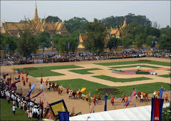

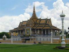

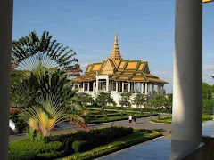
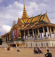
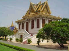
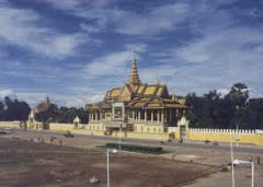
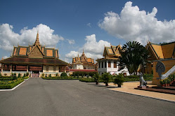
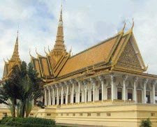

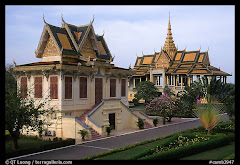


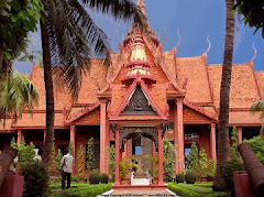
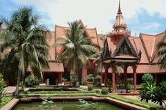


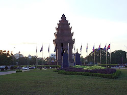


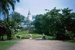

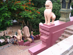
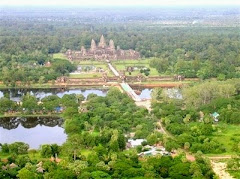
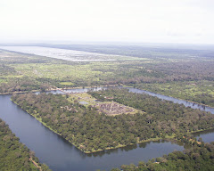

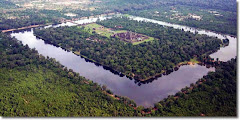
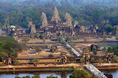
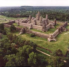
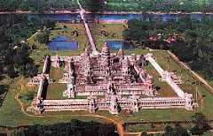
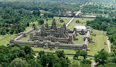
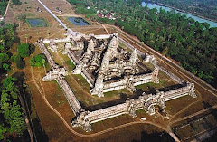

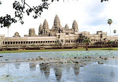

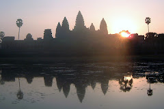
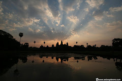
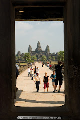
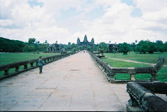
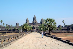
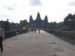
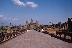
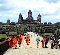
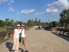
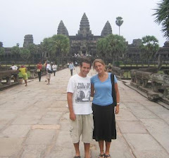
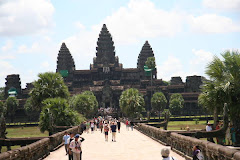
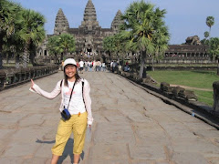
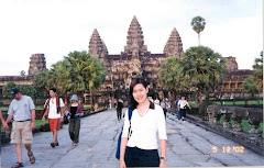

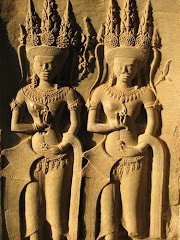

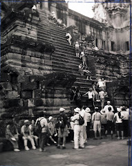

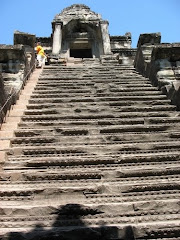

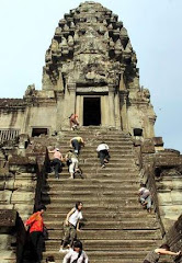
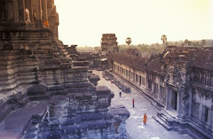
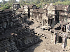
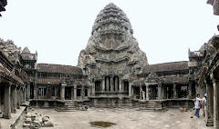
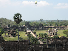


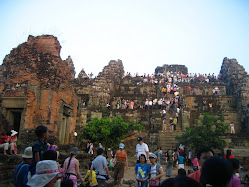

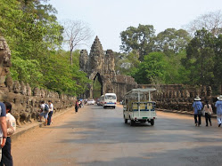

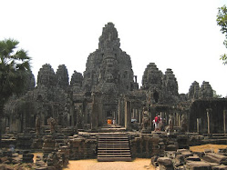
.JPG)
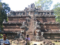.jpg)

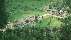
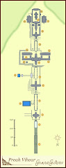
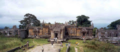
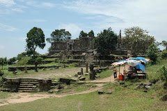

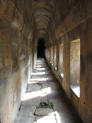
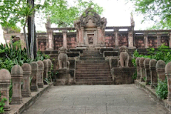

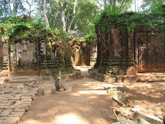
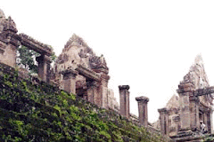
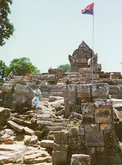
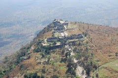
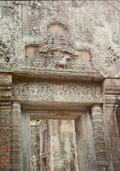
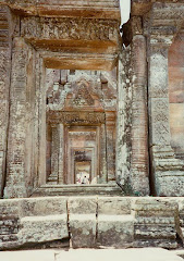
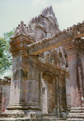

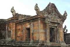

